
When I was a snarly teenager, my mom used to stay the most annoying things. One of my least favorite was “If you put things away, where they belong, when you have them …” followed by a very pointed look at whatever it was I’d laid down on the counter or the table or wherever. It used to drive me nuts. If I could get away with it, I’d stomp off to my room and slam the door, leaving the objectionable object where it was. Often this was accompanied by “I’ll put it away in a minute mom, JEEZ!” Usually, though, I had to very begrudgingly pick the thing up and put it away right then and there. Oh the injustice! Another annoying thing she used to say was “the longest way ’round is the sweetest way home,” usually said in a super annoying chirpy-happy voice while I was stuck in the back seat of a car – hot, motion sick and miserable. What?!? This didn’t even make any sense to me. Presumably home is the place you’re wanting to go in this scenario, right? Of course everybody knows that you’d want the fastest, shortest way to get there. Stupid parents.
 This last saying of hers kept running through my mind on our latest hike. Last time out, we had planned on taking another one of the hikes from Johnny Molloy’s 50 Hikes in Alabama – #12 Natural Well Loop – but decided not to because they were running the Mountain Mist 50K Trail Run that day. We’d heard that something like 400 people had signed up so we figured parking would be a nightmare plus all the trails on our proposed loop were part of the Mountain Mist route so we’d either be stepping off trail all the time to let the runners pass, or even worse, holding somebody up and ruining their race! We ended going to Muscle Shoals instead, but the idea of going to Natural Well again stuck with me and I insisted we do it this weekend.
The last and only other time I’ve hiked to the Natural Well was years ago. We parked at the Land Trust parking lot on Monte Sano Boulevard across from the entrance to the Burritt Museum and took the Natural Well trail straight to it. Coming from that direction, Natural Well trail is an old roadbed and so it was a fairly short and easy hike. I remember being astounded that such a cool geologic feature was so accessible and yet I hadn’t even known it was there! However, in the intervening years, a landslide across the trail that was initially just a bit of an annoyance has eroded to the point where it’s really pretty hard to get across. At least it was around 2014 when we walked that way to see if we would be able get through. I was still working my way back to full mobility from my broken ankle so coming to the landslide area and just seeing a jumble of rocks uphill and downhill and pretty far across made me decide my ankle wasn’t up to it.


This time we were going to take the long way around, starting at the picnic area in Monte Sano State Park and piecing together parts of four trails to make a figure-eight loop. From the parking lot, the McKay Hollow Trail is a gravel path down one edge of the picnic area towards the overlook. It’s easy walking, but only for a little ways. Just past the stone gazebo at one end of the overlook, the trail bears to the right, past the “DANGER HIGH BLUFF” sign, and then right over the top of Blue Springs Falls. This is a beautiful fall that drops about 15 feet by my estimation. It often doesn’t have a lot of water, but the day of our hike had a nice little flow going. After crossing the top of the falls, the narrow and rocky trail does a switchback to a better vantage point for the falls, then continues on down through McKay Hollow. There are some great overlooks on this higher part of the trail – including a spot with these mysterious man-made circular structures, and one just past that overlooking a huge slab of rock that looks like it’s cleaved off onto the bluff shelf below. Just after the big rock, the trail does another steep switchback to get down onto a shelf along the hollow, before heading very steeply down again. This section had some pretty big “steps” down – rocky places where it was not quite rock-climbing, but not something I was able to just walk down – I had to use my hands as well as my feet to make it. I kept thinking about the Mountain Mist runners – how on earth does anybody run 50K – longer than a marathon which is already more than I could ever manage – on terrain like this? Crazy, and yet the official race results web page listed 296 people that ran at least some part of it, and 258 of those finished the whole thing. Wow – just wow.


Part way down this steep stretch, we came across a young man who had rigged up a slack line across the hollow. A slack line, or high line, is webbing stretched between two anchor points that somebody walks across – sort of like a tightrope but with a lot more give. He was resting between walks so I didn’t get to see him cross, but I chatted with him a bit while Chet was still scrambling down the hill above me. He said that he’d love to make a living traveling the world doing highline, but he wasn’t good enough yet. He had fallen twice already that morning and had scrapes on his arms to prove it. The mom in me was appalled, but he assured me that he had a safety harness and that it had saved him – he hadn’t hit the jagged rocks below after all. Ah youth – he was probably rolling his eyes at my momness, but he was very nice about it all. We wished him well and continued on our way.


Just below, at about .8 mile into the hike, the trail levels out a bit at Blue Spring and then McKay Hollow trail continues across Blue Spring Creek while our route, on Natural Well trail, peeled off to the right. In only .1 mile, though, there’s a junction with the Arrowhead trail. We took off to the right on Arrowhead, and would end up at this junction again near the end of the hike. This part of the trail was an easy walk – especially after the scramble down McKay Hollow. The path was pretty level, with a rocky bluff above us. I spotted a deer that must have thought he was part-mountain goat scrambling up the rocks at one point, but of course he was too hidden in the trees for a good picture. At 1.3 miles in, the trail crosses the rocky stream bed of McKay Branch and heads back up the other side of this little hollow until you reach a four way intersection where Arrowhead meets up once more with Natural Well trail. We’d come to this intersection again later in the hike, but for now, we turned right and headed uphill again on Natural Well.


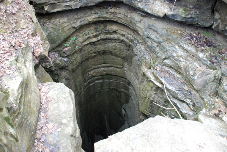
This is another pretty steep section where the trail takes a number of switchbacks and crosses over dry stream beds before finally topping out at the main attraction of the hike, Natural Well. This pit cave is reported to go 190 feet straight down, then slopes to a total of 325 feet underground. From there apparently there is an 1150 foot horizontal passage that can be explored if you get a permit from the State Park office. I’m not a caver, so that part of it doesn’t really appeal to me. Just the hole in the ground and the beautiful layered rocks in the opening were enough of an attraction for me.
We stopped here briefly for lunch and some pictures, but then headed on up Natural Well trail towards the hikers’ parking lot on Monte Sano Boulevard. This is the section of the trail that is an old roadbed, so the going is pretty easy after a brief climb up past an old CCC building. Chet did some research and discovered on old Huntsville maps from the 1930s that the CCC camp for the men who worked at the state park was right here. That’s why the road was there, and the stone building is probably the remains of some utility building for them. The old road hugs a long rockhouse along the base of a bluffline for a stretch and then levels out. I was wondering if we’d have to cross that blasted landslide area before we got to our next trail junction with the Arrowhead, but nope – we found the Arrowhead at 2.8 miles with no landslide in sight.


Though we were not on a roadbed anymore, the path here is a narrow but easy one that wanders gently downhill through the woods. I saw another deer in this stretch – well only “deer booty” this time as one bounded away just downhill from us. This section also had more smoketrees in one place than I’ve ever seen in my life. I’d never heard of smoketrees before we came to Alabama, but the American smoketree is native to rocky mountain soils in Kentucky, Tennessee and northern Alabama. It’s small and has very dark gnarled branches. Frankly usually I have to look twice to make sure it’s a smoketree and not a dead grape vine. One giveaway is the orangy-yellow color of the heartwood. They’re not rare, I guess, but you don’t find them on every trail so they must be selective about where they grow.
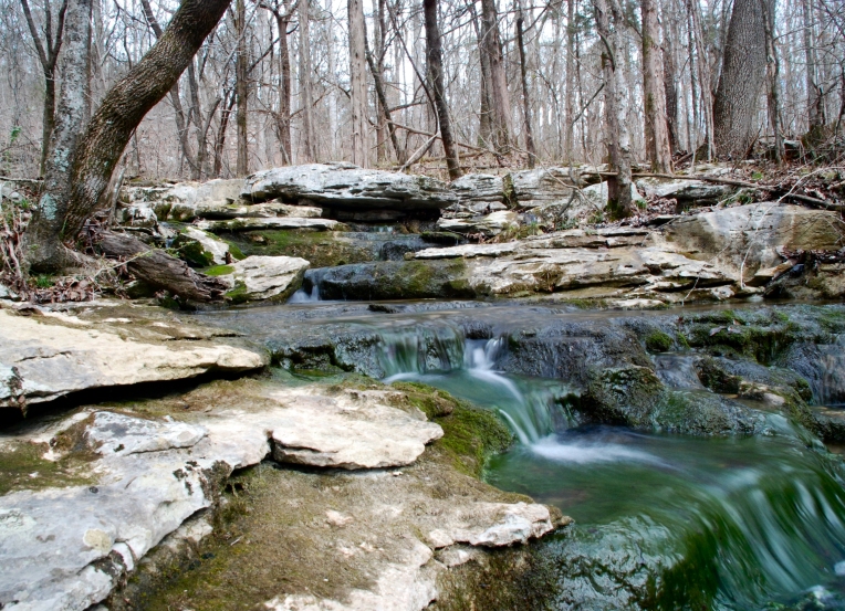
Another fun feature on this stretch of the trail was a marker tree. We always love looking for these when we’re out hiking and were excited to find one on this hike. We dutifully took a compass reading and marked a waypoint on the GPS so we could report it to the Mountain Stewards organization. About .5 mile farther along, the trail splits with the bike trail going straight ahead and across a beautiful little branch. We couldn’t resist checking it out for a bit before we went back to pick up the hikers’ trail, which leads to an old cistern. Here, water rushes out of the mountainside and then collects into the cistern – a low cement walled structure that just pooled up the water a bit before letting it flow on down the hill to the beautiful cascades we’d just visited. While we were here, it occurred to us that maybe this is what the marker tree was pointing to, so we marked a waypoint on the GPS and checked it out when we got home. After loading in the GPS track, Chet plotted the angle between the marker tree and the cistern. We had put the waypoint for the tree actually on the trail, instead of right at the tree, but we had used our iPhone compass app to check out what direction the “nose” was pointing – 161 degrees. The angle the map tool calculated from the tree waypoint (remember it a couple of yards away from the tree) to the cistern waypoint was 158 degrees! We’re almost positive that tree was pointing to the location of the spring that the cistern was built around.


From the cistern, the hikers’ trail rejoins the bikers’ trail to become just the Arrowhead trail again. At 4.1 miles in, the Arrowhead continues on but we took a .1 mile connector trail called the Big Cat Hill Bypass as suggested by the book. I’m glad we did, too, because this next stretch, nice as it was, did sort of seem to go on forever. From the Big Cat Hill Bypass junction, it was another 1.4 miles to the four way trail intersection of the Arrowhead and the Natural Well trails. This time, we took the only path from there we hadn’t yet been on – turning right to go downhill on Natural Well. This part of the trail might have been the most challenging of the whole hike. The footbed was muddy and steep and narrow. Again, I can’t imagine running down it, and I think it was on the Mountain Mist route! The trail bottoms out at the lowest point on the hike at McKay Branch. We rock hopped over the streambed then headed back up along Blue Spring Branch – another steepish segment with another stream crossing – before finally coming back to that first trail junction of the Natural Well and Arrowhead. At this point, we’d completed the figure-eight of the hike, and just needed to retrace our steps out past Blue Spring itself and back onto McKay Hollow trail and the switchbacks up to the falls and the picnic area. We did have a bit of a scare though – just as we were starting up the hollow there was a mighty crash and then the sound of something heavy careening down the steep hillside. I was really afraid I’d see our slackline friend tumbling down the hill and breaking bones, but it turned out to be just a big rock, dislodged while he was trying to get his rigging down.


The hike back up was pretty uneventful otherwise. It was just as steep going up as going down – Chet said his arms hurt a bit the next day from hauling himself up some of those rocks on his poles. We saw quite a few people enjoying the day – a few runners, a lady hiking with her dog, a family with a couple of young kids climbing the big boulder, and a mom and two not at all snarly teenaged girls.


Naturally, time has changed my perspective a bit and I now see that both of Mom’s once annoying sayings had wisdom I was blind to at the time. It is easier to put things away when they’re in your hand and that has the added benefit of avoiding some of the frantic “where did I PUT MY KEYS” melt-downs I’ve been known to have. As for the “longest way ’round” concept that I thought was so stupid, I get now that it was shorthand for the idea that things you have to work harder for are all the more satisfying when you finally reach them. So it was with the Natural Well trail for us. As we were walking on the Big Cat Hill Bypass Chet and I both agreed that this set of trails might be our favorite hike we’ve ever taken in Monte Sano State Park. And you know what? If our objective had been to just get to the Natural Well, and we’d been able to go the easy way, we would have missed so much – the falls, the slackline dude, the deer, the marker tree, the beautiful unnamed cascade and the historic cistern. The longest way round was, after all, the sweetest way.

Wow, that is so cool about the marker tree!! And I’ve never seen that natural well, I don’t think- very impressive!
LikeLike