Where, you might ask, is Tennessee’s second-largest state park? Well, it’s just up the road from Chattanooga. And it’s near Soddy-Daisy. And it’s not far from Dayton, and just outside of Spring City, Caryville, and La Follette, and the northern edge is at Cumberland Gap. If you know your Tennessee geography, you might be thinking that’s a very large park indeed, as those cities pretty much span the state from south to north.
And that’s exactly what the Justin P. Wilson Cumberland Trail State Park does. It’s a linear park, which is a relatively new concept in land preservation. Linear parks are typically very long and very skinny — just wide enough to protect a trail corridor. They usually link public lands of various types, with strategic purchases or right-of-way agreements to bridge unconnected parcels, and often interconnect with other trail systems. A well-known example at the Federal level is the Appalachian Trail, which is actually a unit of the National Parks Service. As a National Scenic Trail, the AT is administered and cared for by a hodge-podge of federal, state, and local governments and a large number of hiking clubs.
The Cumberland Trail is an ambitious work in progress. When finished, it will be around 300 miles long, running from Chickamauga-Chattanooga National Military Park at Signal Mountain to Cumberland Gap National Historical Park on the Tennessee/Kentucky border. At present about 210 miles can be hiked, with the remainder of the trail on state-owned land estimated to be completed in 2019. The trail is divided into segments of varying lengths, with directions to trailheads and points of interest documented for each section on the excellent Cumberland Trail Conference website.
Ever since I found out about this park, I’ve been keen to hike a segment or two. A nice long holiday weekend gave us the chance to make the slightly over two-hour drive to our selected segment: Soddy Creek Gorge South. Many of the completed segments are fairly long — a few even have overnight camping spots — but we wanted something we could do as a day hike since we needed to be back home that evening. Soddy Creek Gorge South is a 4.9 mile segment with trailheads relatively close, but it did mean we’d have to have a shuttle vehicle. Ruth and I drove up separately through light rain to Chattanooga, where we took US Highway 27 north to Soddy-Daisy, then headed up onto the Cumberland Escarpment via the somewhat terrifying Mountain Road (yeah, that’s its name — apparently “Pray You Don’t Meet Anything Bigger On the Way Down Road” was already taken) and Mowbray Pike. Mountain Road/Mowbray Pike is a narrow, extremely winding road that snakes its way up the escarpment. We elected to drop a vehicle at the Mowbray Pike trailhead, and to start our hike from the Little Soddy trailhead.
 For this segment at least, road signage is clearly not a priority. Though Google Maps did have both trailheads as navigation points, we sailed right on by the Mowbray Pike parking lot, which is reached by a short, narrow gravel road angling away from the direction of travel (if you’re coming from the south). There is no sign on the road to direct you to the parking area, so when your GPS says you’re getting close, better strap on your eagle eyes.
  After dropping a vehicle in the parking lot (a nice gravel lot with room for several vehicles), we drove north to the Little Soddy trailhead and parked in a small unmarked pullout at the junction of Hotwater Road and Sluder Lane.
This segment of the trail starts as a spur trail about 200 feet north of the parking area on Hotwater Road. With no fanfare (or signage), the trail enters the woods, where we immediately spotted a kiosk next to a small, unnamed branch off Little Soddy Creek. We descended a brief rocky and rooty decline, crossed a wooden footbridge, checked out the info on the kiosk, and headed on down the blue-blazed trail. A word about the blazes — typically in Tennessee state parks, the main trail is blazed white, and spur trails are blazed blue. That’s not always true in parks with extensive trail systems, though. In this particular case, the Little Soddy trailhead is not actually on the Cumberland Trail — it’s at the end of a .4 mile spur, so for the first part of our hike we were following the blue blazes.


After the kiosk, the trail levels out and winds through an open understory roughly paralleling the creek. This is a historic site, as there were many coal mines scattered about the general area. There aren’t any open mines on this segment — all of the ones that we saw were collapsed. Small signs marked historic sites, but we didn’t have the brochure available from Cumberland Trail website, so we weren’t ever sure of what we were looking at. The kiosk at the trailhead has a place to distribute brochures, but it was empty at the time of our visit. Since we didn’t have the info, and the annoying light rain was continuing, we plowed on ahead instead of taking the yellow-blazed loop toward more historic sites. This part of the hike was quite nice, as the trail dropped into a hollow and crossed Little Soddy Creek on a footbridge with a mountain laurel blooming next to it. We spotted a flame azalea, one of our favorite backcountry sights, well off the trail but didn’t bushwhack to get a better look, thinking we’d see more of them (we didn’t).


At .4 mile, we reached the connection to the Cumberland Trail proper. We turned right to follow the route to the Mowbray Pike trailhead. A note about trail distances — they seem to be a bit vague in this section, at least.  According to the trail signage, our total distance from trailhead to trailhead would be 4.6 miles. The Cumberland Trail Conference website says it’s 4.9 miles, and the Tennessee State Parks website says it’s 4.42 miles. Our GPS track came out to 5.0 miles, though we did a little off-trail wandering. That might suggest that the Cumberland Trail Conference website is the most accurate, but we found the mileages to the various points of interest listed on the CTC site didn’t match up with our GPS during the hike. It might have been weirdness with our GPS, but based on our very limited experience I’d say don’t get too hung up on the mileage, and assume any distance has a plus or minus 10% margin of error.
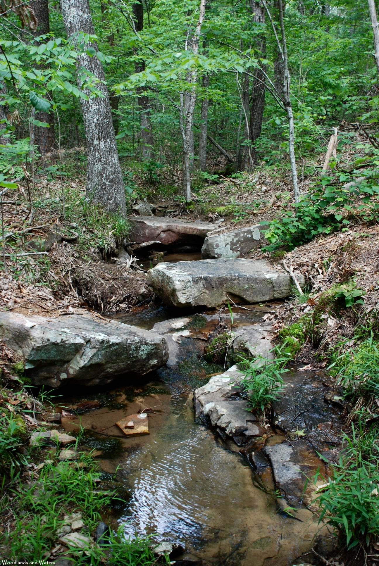
Once we were on the white-blazed Cumberland Trail, we wound along the coal vein, with Little Soddy Creek to our left for a while. At times we were on an old roadbed; other times, we were on a narrow footbed. Very occasionally we saw artifacts from the mining days, such as a coiled length of iron near one of the footbridges. This section of the trail was relatively low and wet, though the trail is well-engineered and drains nicely, with well-placed stepping stones, stairsteps, and creek armoring. The abundant water no doubt contributes to a number of wildflowers and ferns in this area, such as running cedar, dwarf crested iris, whorled coreopsis, spotted wintergreen, and bowman’s root just to name a few.


 The trail had been inching uphill away from the creek, and at about 1.3 miles made a hairpin turn and begin climbing up the ridge to Clemmons Point. The change in elevation brought into view the first of several rock formations we’d see along this piece of the hike, though views to the east were largely blocked by the trees.
  The drier conditions led to fewer wildflower sightings, though by this time we had recorded over ten wildflowers and earned ourselves our customary post-hike ice cream treat. We did spot a nice stand of white milkweed in bloom.
The trail undulates a little in this section, dropping from a narrow path along the top of a mine tailing to the bottom of a former strip mine trench. For the most part, however, the trail stays high and eventually begins passing impressive rock formations on the right. The trail levels off for the next couple of miles, with rocks to the right and occluded views of the valley to the left. In this section, at around mile 2.7, the white blazes were sporadically supplemented by fresh-looking bright orange blazes, often above eye-level. The white metal blazes were no longer in use, but there were still faded white paint blazes from time to time. It was a little confusing, but we hadn’t passed any obvious trail junctions, and none are shown on the map, so we kept rolling along.


 The rain had stopped about the time we reached Clemmons Point, but I was still a little grumpy, complaining that the trail was very nice, but this section didn’t have any unique features. And right on cue, a little forest denizen popped up on the side of the trail — an Eastern box turtle. Needless to say, Ruth was delighted! We snapped a few pictures of our little friend and left her to continue her journey.
The trail continued southwestward, staying level and relatively straight as it passed more impressive rocks, including one that had a sizeable tree growing through a crack. Several times during the hike we crossed over coal seams, places where small bits of coal were visible on the surface. It reminded me of our hikes on Ruffner Mountain except of course the surface minerals there are iron ores.


 After crossing a small stream at about 3.6 miles, guess what was waiting for us in the center of the trail? Yep, it was ANOTHER Eastern box turtle! (I’m certain it was a different one — we’re slow, but we’re not THAT slow). In all our years of hiking, we have never seen two different land turtles on the same hike. We paid our respects to the state reptile of Tennessee, and edged past him.
 At about mile 4.0, after passing more impressive boulders and bluffs, we noted one bluff with a sizeable overhang that the CTC identifies as a rock house.
  We didn’t explore this particular one, but at mile 4.3 a short side trail leads to a small rock house that has been confirmed as a Native American site by an archaeologist. We detoured briefly to check it out, before continuing to the most interesting section of this segment.
At about 4.4 miles, the trail passes between two large rock formations, in a feature known as the “Little Stone Door.” This narrow open passage is reminiscent of its namesake, the nearby “Great Stone Door,” which we have previously described.


 The clarion call of a waterfall sounded as we walked through the Little Stone Door, and indeed a small waterfall tumbles down from a ledge. I couldn’t find a good vantage point to photograph the entire drop of Mikel Branch, but bushwhacked down the hill far enough to get a look at the bottom portion of the falls.
  It’s possible that the bottom of the fall is outside the park boundary, and as we made our way back uphill we came across one of the higher portions of the cascade, on the back side of one of the large boulders. Keep an eye out for park boundary markers in this area, but also follow the sound of water to see pretty cascades if you can do so without trespassing.
Once we rejoined the trail, we continued to the west, crossing Mikel Branch on a footbridge before passing through a powerline cut with an impressive view down into Soddy Daisy, with the Tennessee River and the cooling towers of the Sequoyah nuclear power plant visible to the east.  After crossing one last stream and one last coal seam, this segment of the Cumberland Trail heads uphill for its last .2 miles before descending into the parking lot at the Mowbray Pike trailhead. After picking up our shuttle vehicle, we made our way down to Soddy-Daisy, where we had our ice cream treat at Sonic, then made our way home through several heavy rainstorms.
So, that’s 1 segment down, and 28 to go (of the current sections — there are many more to be added). Or, if the trail is going to be around 300 miles long, we’ve covered about 1.67% of it. That’s not really enough to do any generalizing, but we did form a few impressions of this segment. On the plus side, this segment is very well engineered, with good drainage and reasonably good marking (the orange blazes stopped near the Little Stone Door, and the white metal blazes returned). We never saw another hiker at any point on this segment, so the solitude rating would be quite high. There were many scenic rock formations, historic sites, some pretty creeks, and a very good selection of late spring/early summer wildflowers. And of course, two turtles!
On the minus side, this segment is rather secretive, with no signage on the roads to identify the parking areas.  Also, it’s in need of some general maintenance, as a few sections are overgrown with poison ivy lurking in the narrowest sections, and there are several downed trees. The trail is still navigable, with stepovers and a few places where you’ll have to skirt the deadfalls, but it would benefit from some attention from a sling blade and a chainsaw. Changing to orange blazes halfway into the trail, without any description of this in the trail description on the CTC site, is a little unnerving, and almost caused us to do some unnecessary backtracking to make sure we hadn’t missed a trail junction. This is not meant to nitpick with the fine volunteers who build and maintain this trail — it’s just meant as a heads-up to any of our readers who fancy hiking this segment.
Overall, this was a very enjoyable introduction to the Cumberland Trail, and we’ll certainly be back to do other segments. We have no illusions of being AT thru-hikers, but maybe the Cumberland Trail would be achievable for us as segment hikers. Of course, if we get ambitious (and win the lottery), we might just finish the Cumberland Trail and just keep going on the Great Eastern Trail, which is a yet longer trail planned to run from Alabama to western New York State. The Great Eastern Trail will be around 1,600 miles. And it looks like the Pinhoti Trail will be part of it, so the seven miles or so that we’ve hiked on the Pinhoti puts us at about 0.4% along the way of completing the Great Eastern Trail. Well, a guy can dream, can’t he?