It was a quiet year for our little blog, chugging docilely into its seventh year. As retired persons, Ruth and I have continued pursuing efforts important to us, now that we have leisure time available in nearly unlimited quantity. Now that we do only what we want to, we’ve chosen to throw ourselves into community service activities. We’ve both put in massive hours volunteering for Friends of Silvermont, a local historic mansion and park, and their annual Pumpkin Fest fundraiser. Ruth has been very active in the local chapter of the American Association of University Women (AAUW), a group that I jokingly say runs the town (but they do). I’ve been participating in reader’s theatre at Silvermont (it serves as our local senior center), with a couple of public performances toward the end of the year, and taking a guitar class. Ruth has been one of the organizers of a group to bring together new and established Brevard residents for informal get-to-know-you events. The calendar is surprisingly full.
So as you might guess, we weren’t filling up all our time with hikes and outdoor adventures. But we did manage a few, and we even blogged about some of them. In 2022 we put up 10 posts, as compared to 25 posts in 2021, so our output was way down. A lack of new content to drive people to the site was reflected in our viewing stats, as expected. Even so, in a year in which we put forth minimal effort we still generated 23,133 page views from 12,907 visitors. Compared to last year’s 37,669 views, that’s about a 39% drop. We had 20,283 visitors in 2021, so that’s about a 36% drop in 2022. Considering that we put up less than half the amount of new content, that’s not all that bad. About 97.7% of our views came from the U.S., with views from nine different foreign countries.
We like to track which individual posts had the most views over the year, and once again two perennial favorites emerged to claim the #1 and #2 spots. The evergreen A Comparison of Three Southeastern Hike-in Lodges had 897 views in 2022, just nipping Marker Trees and Indian Tomb Hollow to the top spot with 895 views. These are old posts, so they’ve had plenty of time to get ensconced in search engine results. Our most popular of the 2022 posts was a tie between Local Color: Bracken Mountain Preserve and Next on the Docket: Devil’s Courthouse, each with 40 views. The Bracken Mountain post, from January 2022, documents a November 2021 hike. Our busiest month of 2022 was March, with 2,734 views.
There’s one unique thing about 2022, our first full year in North Carolina. Previously, we blogged on nearly every hike we took. In 2022, we didn’t get out on the trails quite as much, and we blogged about only a handful of our hikes. According to the blog posts, we hiked a total of around 46.73 miles. Ruth keeps a separate spreadsheet to track miles on all hikes, when we remember to record the mileage, and we actually covered around 85.25 miles in 2022. So, roughly speaking, we actually hiked about twice as much as our blog would suggest. Our shortest hike, going by the blog posts, was a 1.5 mile hike at Upper Whitewater Falls in the Nantahala National Forest. Our longest hike was a 7.2 helltrek on the Green River Cove Trail in the Green River Game Land in Polk County, NC. For the first time in the history of the blog, all hikes were done in one state, though we did have a couple of hikes in South Carolina that we didn’t blog about.
Of the hikes that we did blog about, we traveled in a city park, national forests, state forests, game lands, one unit of the NPS, and private preserves. We both had the same favorite hike in 2022 — our little jaunt to Upper Whitewater Falls, described in the post I Found My Thrill. We had done this hike previously, and reluctantly re-visited as part of White Squirrel Hiking Challenge 6. We caught the trail in a magnificent wildflower display, easily the best we’ve seen so far in North Carolina. Speaking of that hiking challenge, completing it was the hiking highlight of the year, with some particularly memorable trips. We’re looking forward to the 7th version of this challenge, and might even go back and finish some of the previous years’ iterations.
I’ve included a few favorite photos from hikes in 2022. Some were included in blog posts, and some are making their debut in this post. We might comb through the archives and write up a few of the 2022 hikes in 2023, or some of those photos and memories will remain unpublished. We do what we want to! But we’re glad that our content from the Tennessee Valley is still being looked at, and hope that over time we’ll build a similar following in North Carolina. Happy 2023 everyone, and get out there and have some outdoor adventures!
Eastatoe Trail, JanuaryHooker Falls, JanuaryLittle Bradley Falls, FebruaryJohn Rock, FebruaryBiltmore Estate, MarchOconee Bell, Devil’s Fork State Park, MarchPearson’s Falls, AprilSam Knob, AprilCatesby’s Trillium, Upper Whitewater Falls, AprilWintergreen Falls, MayGraveyard Fields, AugustFrolictown Falls, AugustGreen River Cove Trail, SeptemberYoungs Mountain, SeptemberReese Place Falls, OctoberHeadwaters State Forest, November
It’s time for our annual look back at the previous year for Woodlands and Waters. 2021 was a big year for us in terms of life changes, and that is reflected in the blog, which like us, underwent some changes over the past 12 months.
We started Woodlands and Waters in 2015, so we’ve completed 6+ years now. As we built a body of work with weekly posts, our viewership stats grew to reflect that people were finding our posts, though we’ve rarely done anything special to promote them. The overall pattern of viewership stats has been a steady increase year over year, with 2020 being a bonkers year due to folks being locked down and looking for outdoor escapes. We had a whopping 54,557 views in 2020, with 29,531 visitors. However, 2021 was more of a return to form, with only 37,669 views and 20,283 visitors. We expected that viewership would be down as people resumed their normal activities, but if you ignore the statistical outlier of 2020 and look at our 2019 stats, we’re actually up almost 80%.
There were two significant changes to Woodlands and Waters in 2021, driven by changes in real life. We both retired at the end of 2020, which you’d think would give us time to hike and blog even more. But we were both crazy busy at work during those last few months trying to get things wrapped up, so when January 2021 rolled around we were finally able to focus on the next part of the life plan — to sell our house in Alabama and move to North Carolina. This led to a frenzy of repairing and painting and power washing and evaluating/tossing/selling/packing 28 years of accreted possessions. And finding a new place to live … and working out the logistics for the move … and unpacking and reassembling a smaller amount of that stuff into a significantly smaller house and a significantly bigger storage unit. So suffice it to say, some demands on our time had to be sacrificed, so we stopped making weekly posts.
Now that we’ve settled in (somewhat) in western North Carolina (WNC), and we have a year’s worth of retirement under our belts, our motto has become, “that sounds like work!” We’ve been active in the community, and we’re getting out and enjoying the reasons we moved here in the first place – visits with family and hikes in and around the mountains. Blogging weekly, however, sounds like work, so we’re being intentional and not blogging about every walk we take. Ruth made an important structural change to the site, as future posts will be WNC-centric. The posts still appear in chronological order, but our Trails page has been split into two pages, one for Alabama trails and one for North Carolina. We need to make similar changes to the Waterfalls page, and maybe I’ll finally get around to fleshing out the Wildflowers pages. I don’t know … that sounds like work.
Nonetheless, we did manage to put up 25 posts in 2021. 14 of them are new content based in the Tennessee Valley, 4 of them are quick looks (short recaps of previous blog posts), and 7 are new content from hikes in WNC. This is in marked comparison to our 53 posts in 2020. However, this is a more sustainable level of effort for a couple of retired folks who are finally turning to projects put off until retirement (genealogy; music lessons; and digitizing a multi-generational collection of family movies, slides, documents, and photographs, just to name a few).
As is the custom in this year in review post, here are a few other stats we thought you might find interesting.
Of our 37,669 views in 2021, 36,546 were from the U.S., as you’d expect. We had views from 82 different countries.
Our top performing post for the year was the old standby, Marker Trees and Indian Tomb Hollow, first published in 2015, with 1,463 views. The second best was A Comparison of Three Southeastern Hike-in Lodges, also from 2015, with 1,106 views. Obviously these are still of interest to our readers, though their performance is probably related to their age (i.e., the opportunity to have been linked to by other people) and likely their search rankings.
January 2021 was our busiest month, with over 6,000 views of various pages on the site.
We hiked 62.6 miles as documented in the blog posts. We actually hiked farther than this during the calendar year, since we’ve completed some hikes in WNC that we’ve not blogged about. Some will be covered in posts in 2022; some won’t. This is the first time that we’ve had hikes “on the hook” for us to write about later.
Our shortest hike of the year was 1.16 miles, a round-trip on the Land Trust of North Alabama‘s Wildflower trail.
Our longest hike of the year, at least as recorded in the blog, was 6.31 miles on a ramble in WNC’s Panthertown Valley.
We hiked in three states this year: Alabama, Tennessee, and North Carolina.
We hiked in various types of recreation spaces: state parks in Tennessee, North Carolina, and Alabama; two private reserves; National Forests in Alabama and North Carolina; state forests in Tennessee and North Carolina; and properties owned by one land trust.
Ruth’s favorite hike from 2021 was a multi-waterfall trek at Cane Creek Canyon Nature Preserve. Chet’s favorite was our loop in the Panthertown Valley (linked above).
2021 was a year of transition for us. However, for many people it was a year of sacrifices and losses. We’ve been fortunate, as we’ve stayed COVID-free (as far as we know), and though we’ve had some family members who weren’t so lucky, all have recovered. Sadly, we did have one loss in 2021: our beloved Casey The Hound, our erstwhile hiking companion until he became a Retired Dog.
Ruth and Casey, 2012Snow day, 2015
So what’s up for 2022? More hiking, of course. We haven’t blogged about it, but we recently completed the Conserving Carolina Flying Squirrel challenge, in which we had to complete eight visits to properties saved or developed by this excellent land trust. (For long-time readers, Conserving Carolina is the local equivalent of the Land Trust of North Alabama, so it’s natural that we would gravitate toward them.) We completed a float trip on the French Broad River as part of this challenge, and made a visit to the highest point in South Carolina. We’re also working on Conserving Carolina’s White Squirrel hiking challenge, which requires eight hikes to specific locations (three down and five to go). We’ve barely dented the 1,000 miles of trail just in our county, and the same is true of the purported 250 waterfalls.
Here are a few of our favorite photos from Woodlands and Waters in 2021, plus sneak previews from future posts and a few bonus ones from hikes that won’t get their own blog posts. Though we’re not posting as often, we’re still trying to get out on a more or less weekly basis. For us, at least for now, hiking does not sound like work.
Last week, we broke a streak of posting new content, or at least a quick look, every Wednesday on Woodlands and Waters. We missed our deadline again this week. So what’s up with us?
Well, we have been busy over these last several weeks. We both retired in December 2020, and since then we’ve been slowly decluttering the house and working on long put-off projects. It has been our plan for quite some time to move to western North Carolina to be closer to family and the mountains, and it made sense to try to time the move for the spring house-selling season. The real estate market has been incredible in most parts of the country, and the same holds true in the Huntsville, Alabama area.
So our lives recently have been a blur of painting, carpentry, pressure washing, weeding, mulching, carpet installation (we paid someone else to do that!), and sorting through the accumulated detritus of living in this house for 25 years. We finally got the place ready for photos this past Monday, and it went on the market Thursday. So now we’re just waiting on the offers to come rolling in!
So what’s next? Assuming we get an acceptable offer, that will start the clock for our move to North Carolina. We’ve already rented a place there, so now we’re straddling two worlds — the past in Alabama and the future in North Carolina. Now our retirement plan shifts into a new mode: preparing for the move. That will entail the logistics of moving the contents of the house and storage unit into a smaller house and a different storage unit hundreds of miles away. Somehow, I don’t think we’re going to find ourselves with much idle time in the next few weeks.
Which brings me to the question of what is going to happen to Woodlands and Waters? In the short term, we are not going to be posting weekly, and in fact we may not post at all for a little while. Our tagline is “Outdoor adventures in the Tennessee Valley and beyond,” so we could theoretically keep on chugging along from our new headquarters. Or we could start a new blog … or take a break from blogging … we’re putting off making a decision until after the move.
But we have made one decision already. We’ve signed up for another year with WordPress, so all the content on Woodlands and Waters will still be around for a while. Maybe in post-move retirement we can get around to updating our long-neglected wildlflower pages. Anyway, if you’ve gotten in the habit of checking on us weekly, know that we’re temporarily sidetracked so you won’t be seeing much new content.
Like any move, it’s bittersweet to think about the things we probably won’t get to do in our current location. But on the other hand, we’re moving to a place that claims to have 250 waterfalls and over 1,000 miles of trails in the county. Now that’s a target-rich environment!
Sunday was a lovely day, with clear cool skies and temperatures warming into the 60s. We were in a historic state park, new to us, on a loop trail with lovely lake views. The trail was beautifully maintained, with reasonable occasional ascents and descents. Folks we met on the trail were courteous and enjoying themselves. So why am I so angry as I’m writing this post?
I think it’s because I’m thinking back farther than just a few days. Our experience this past weekend at Booker T. Washington State Park in Chattanooga, Tennessee was excellent. Other than the visitor center being closed due to COVID-19, our experience was much like it is at any Tennessee state park — plenty of parking, well-maintained facilities, well-marked trails, attractive scenery, all available at no entrance fee. We were made to feel welcome…but more about that later.
Booker T. Washington State Park is on Chickamauga Lake, one of the impoundments of the Tennessee River. Started in 1938 as a TVA reservation, the park is named for the black American leader. A prominent voice in the early civil rights struggle, Washington was born into slavery and worked his way after the Civil War into college, eventually founding the Tuskegee Institute (now Tuskegee University) in Alabama at the age of 25. Through his work at Tuskegee, he became nationally known as a spokesman for education of freedmen and their descendants, aiding in the development of other schools. He came to represent a certain viewpoint that the best route forward for his race was to submit to white political rule in a segregated society, but to advance by receiving basic education and vocational training and being granted due process of law. This approach was known as the Atlanta compromise, as outlined in a speech by Washington in 1895. Given our modern sensibilities this may seem pretty weak, but it was the starting point for the evolution of more ambitious views of civil rights. Though he is known for his “go along to get along” views, Washington secretly financially supported court challenges related to segregation and voting registration. His influence waned after 1915 as other civil rights leaders such as W.E.B. Du Bois rose in prominence.
The state park has a hiking/biking trail system of around 8.5 miles on a peninsula sticking out into Chickamauga Lake on the north end of the park. The trail system consists of a nature trail loop, which intersects an outer loop trail of 3.9 miles. Two inner loop trails are inside the outer loop, so you can construct a number of hikes of varying distances. We opted to hike the Outer Loop trail, which is most quickly reached by a .3 mile segment of the Nature trail. We parked in the paved lot next to Pavilion 1A. The Nature trail begins at the north end of the parking lot next to a kiosk. There are restrooms and a playground uphill to the left, as well as some picnic shelters.
After passing the kiosk, the trail turns to the right and heads into the woods. Almost immediately there are great views of a long lobe of the lake stretching from the main body to the northeast, with easy access to the rocky shore. In 0.05 miles, the trail forks, with both forks seemingly heading in the same northeastern direction. The Nature trail is a loop, so you can choose to go clockwise or counterclockwise. The clockwise option passed closest to the lakeshore, so we opted to go that way. The trail is blazed with blue paint, and is never really labeled as the Nature Trail, but it matches the park’s trail map, in which the Nature Trail is marked in alternating green and blue dashes. Though we never saw any exhibits or labeled trees or plants, later on this loop there is a side trail to something that looks like an outdoor classroom.
The trail has a natural treadway, and this section of the Nature trail heads northeast for .3 miles along the lakeshore. There are several side trails down to the water, and down one of them we saw a great blue heron taking in the view. After we startled it into flying to the opposite shore, we popped down to the bank to get photos up and down the cove.
The trail appears to split at one point along this stretch, but we continued along the path that hugged the shore. It’s a little confusing, as this part of the loop trail is pinched together without actually intersecting, so sometimes the other side of the loop trail is literally next to the footbed along the lake. Just stick to the trail closest to the lake and you’ll be fine. At .3 miles, we reached the intersection of the Nature trail and the Outer Loop trail, which is also blazed in blue. The intersection is marked with a tree with double blazes. We opted to continue hiking clockwise on the Outer Loop, so we headed to the left.
This segment of the Outer Loop heads northeast briefly to the end of the cove, then turns southwest to follow the north shore. There are a couple of plank bridges in this area, as a small feeder creek flows into the cove. The single-track trail has very little elevation change in this section, since it’s only a few feet from the water, but there are a couple of large dips where a drainage has eroded the trail. They were easy to cross on foot, and would probably be fine on a bike but you’ll need to watch out for them.
One of the quirks of hiking along the shore of a cove is that you may see the starting point of your hike across the water. Our friend the heron was still hanging out on this side of the cove, but there was too much underbrush to get a good photo. At roughly .65 miles from where we started on the Outer Loop, we rounded the peninsula and started heading north, with the main body of Chickamauga Lake off to the left. There’s a small overlook here, where we paused briefly to take photos.
Though the trail surface didn’t change here, its elevation certainly did. The climb is gradual, with an elevation gain of 70 feet over the next half mile or so. Chickamauga Lake is visible through the trees, but even in the winter the views are somewhat obstructed. We passed through an area where there had been a large blowdown, but here and everywhere on this hike we saw excellent trail maintenance, never once having to step around or over obstacles. We reached the first intersection with the Inner Loop 1 trail 1.15 miles from where we started on the Outer Loop. This junction was very well marked, with a terrific wooden version of the trail map, complete with a “here” marker so you could place yourself on the map.
You’ll notice from the trail map that the Inner 1 and Inner 2 loops actually have two junctions with the Outer Loop trail. We reached the second junction for Inner Loop 1 about 150 feet down the trail. The next segment of the Outer Loop reached the highest elevation on this hike, about 800 feet, so the trail tended uphill when heading north. The gain in elevation didn’t help much with the lake views. I noticed English ivy climbing trees here, which reminds me to mention that we did see quite a few examples of non-native plants such as privet and nandina. At least the nandina gave the woods a pop of color.
Nandina
English ivy
Our next landmark, at .6 miles from the Inner Loop 1 intersection, was the two intersections with the Inner Loop 2 trail. This intersection is at the northernmost end of the peninsula, where there’s a thoughtfully placed bench that allows you to rest and view the lake to the left and a small cove to the right. We took a brief break here before continuing southeast toward the end of the cove.
After reaching the end of this small cove, the Outer Loop continues away from the water, then turns east. We had not noticed a change in background color on the trail map, so it was a mild surprise when the Outer Loop actually left state park property and continued onto TVA property. The proximity to TVA property isn’t surprising, as the park was originally developed by the TVA and was leased to the state until 1950. The trail climbs briefly in this area, and features three spur trails that connect to Solitude Drive. The spur trails aren’t on the trail map, but they are prominently marked on the trail itself, with the first and third spurs displaying those excellent wooden maps. After the first spur trail, the Outer Loop trail widens considerably as it follows an old road. After the second spur trail, Outer Loop returns to single-track, winding through a gradual descent as it re-enters the state park.
This last segment of the Outer Loop trail largely parallels Solitude Drive, crossing a couple more plank bridges before returning to the junction with the Nature loop trail. To be sticklers, we took the split to the left so that we would complete the Nature trail loop. In retrospect, I wouldn’t recommend this, as this part of the Nature trail closely parallels Champion Road, which is quite a bit busier than Solitude Drive. It’s also longer, as the eastern portion of the loop is .75 miles back to the trailhead by Pavilion 1A, as opposed to .35 miles if you backtrack along the part of the loop next to the lake. If you parked at the pool (there’s a second trailhead there) then it’s slightly shorter to take the split to the left. We went left just to complete the loop, but there weren’t any remarkable features there except a couple of banked turns for bikers. In fact, this segment was one of those annoying ones that winds unnecessarily over flat ground just to give bike riders a little more mileage.
Speaking of bike riders, I understand that these loops are very popular in the Chattanooga biking community. We only saw one biker during our hike (she lapped us three times, I think). The trail maintainers have done a great job of making the Outer Loop bike-friendly, and it’s likely that they’ve done the same for the inner loops.
We completed the Nature trail loop and rejoined the trail back to the kiosk, for a grand total of 3.88 miles according to our GPS track. We made pretty good time on this trail by our standards, finishing in about three hours. Fitter people who don’t stop to take photos will make even better time. On our way out, we stopped by the fishing pier, where Ruth had earlier noticed some historical markers. We paused to learn more about the CCC and Booker T. Washington.
So why I am so worked up about this park? I selected it for a hike during Black History Month for a reason — Booker T. Washington State Park is one of two state parks originally built in Tennessee as black-only parks. Generally speaking, state park development in the South only really took off in the Depression era, as the Federal Government pumped money into the states for grand public works projects. The TVA built recreational facilities, the CCC and WPA built state and national parks, and it was a boom time for public recreation — if you were white. The South was still in the grip of Jim Crow laws enacted during Reconstruction, reinforced by the dreadful Plessy vs. Ferguson Supreme Court ruling in 1896 that established the “separate but equal” principle. As noted by William O’Brien in a 2007 article, “… the ‘equal’ provisions of such laws were never as stringently applied as were the ‘separate’ provisions, and the exclusion of African Americans from opportunities and activities available to whites was the norm.”
O’Brien later wrote a book, Landscapes of Exclusion: State Parks and Jim Crow in the American South (Amherst: University of Massachusetts Press, 2015) that explores this topic in more depth. One illustration in that book shows a map of the southeast with dots representing state park locations, with black dots for each park that had facilities available to African Americans from 1937 to 1962. I didn’t count every dot, but I’d estimate the ratio was about 1:10 overall. Tennessee had 2 parks for black use, with another 15 reserved for whites. Alabama had one park with some facilities for black use (which weren’t built until 1952-53), with another 8 or 9 for whites only. In 1954, in nine southern states there were 12 parks in existence or in the planning stage for African Americans — as compared to 180 white-only state parks.
Don’t make the mistake of thinking that those meager few parks and facilities for African Americans were built out of generosity of spirit. In most cases, those parks were built as “proof” of the feasibility of separate but equal facilities, in a cynical attempt to fool the courts into delaying the inevitable. It was no accident that when Alabama finally came around to adding black-accessible facilities to a state park, it selected a park in one corner of the state — the only Alabama state park to be named after a Civil War general. You won’t find any mention of this in Joe Wheeler State Park’s website or brochures. And when states built black-only parks or facilities, they were often in inferior locations with fewer amenities.
Southern states did eventually desegregate their parks — some by reluctant choice, some because of the passage of the Civil Rights Act of 1964. When forced to desegregate, some states quietly but unhappily complied (Tennessee is one example), and others angrily resisted, privatizing (Georgia) or closing (South Carolina) their parks. Tennessee was ahead of the curve, desegregating all state parks by 1962. Tennessee, to its credit, still operates its two formerly black-only parks (Booker T. Washington and T.O. Fuller State Park in Memphis) under their original names; North Carolina follows suit with Jones Lake State Park. All other formerly black-only parks are no longer in operation, at least as state parks. Some were sold, some were privatized, some were given to county and local governments, some were abandoned. Parks that had separate black and white amenities combined them, usually with no acknowledgment of their segregated pasts.
And here’s where it gets personal. It’s easy for historical events or movements to get pushed into the background if they happened before you were alive, especially if there’s no personal connection. Though Ruth and I were just infants at the time, during our lifespan black people weren’t welcome at the vast majority of state parks. They were shunted into fewer and inferior parks. Fortunately, that’s not the case anymore, but it speaks volumes about why African-American attendance in our parks is well below what you would expect, demographically. Ruth and I have often wondered about this, and now we know that black people in our generation in the South were either excluded from state parks, or their parents were. It’s not that I’m surprised that there was (and is) racism — I’m just furious at the stupidity of it, and at the cynicism of the politicians who grudgingly complied with public pressure, lawsuits, and legislation. They never thought they were wrong, and those are the people who destroy the world.
And this is when it really hit me. Back in December 2019, Ruth and I hiked an area of Joe Wheeler State Park known as the Multi-Use Trail (Ghosts of Picnics Past: Joe Wheeler Multi-Use Trail). This trail, on the south side of Wilson Lake, passes the ruined chimneys of a picnic pavilion, a collapsed gazebo, an abandoned bath house, and damaged and overgrown concrete picnic tables. We were confused about why the park would have abandoned a developed area. In that post, I wrote, “On the other side of the trail, remains of concrete picnic tables stood silent, with occasional grills and ruined water fountains dotting what was clearly an old picnic ground. At one time, it would have been a lovely picnic spot, with views of the river and the dam below. Long abandoned, it was haunted by the ghosts of picnics past.”
Now, unless I’m very much mistaken, I believe we were in the black-only portion of Joe Wheeler State Park, abandoned after the desegregation of the Alabama state park system. It’s known that at Joe Wheeler the black-only section of the park was on the other side of the river from the white-only section. Given that the lodge, the golf course, and the campground are on the north side of the Tennessee River, the south side is the logical location. Topo maps from 1957 show the buildings, dirt roads, and the picnic area; topo maps from 1936 do not show any buildings or dirt roads in that area.
We were standing among the relics of a shameful past — the only state park system facilities in Alabama made available to African-Americans prior to desegregation — and didn’t even know it.
UPDATE, 8 March 2021: Since publishing this post, I have acquired William O’Brien’s book Landscapes of Exclusion (mentioned above), which includes a “sketch plan of Joe Wheeler State Park” that shows the location of the “Negro Recreational Area.” Though my original post had an evocative ending, the truth is that I was indeed mistaken. The actual location of the black-only portion of Joe Wheeler State Park is on the east side of the First Creek embayment, on the north side of Wheeler Lake. It looks like the actual location is north of the present-day First Creek boat ramp, perhaps in the vicinity of the park’s Fisherman’s Cabin. I haven’t examined that particular section of the park, but other than the cabin there are no trails or amenities there now. It’s like the “Negro Recreational Area” never existed, which might be an even sadder end to this post.
Once again, we’ve made it through another year on our little blog so it’s time for a bit of a look back. 2020 was a strange year, as the COVID-19 pandemic wreaked havoc on everything from schools to restaurants to the travel industry to hair salons. However, with much of the indoor stuff closed or limited, the outdoors turned out to be a very popular option. The area trails saw record numbers of people, meaning heavy use, full parking lots, and more trash to pick up. We also saw the impact on our little blog. WordPress provides a handy stats page, which we check from time to time. We were astonished to see our daily average number of views jump from about 57 to 147 views a day! For the year, we had 54360 views (as of Dec. 30), which is an increase of 159% over last year. Crazy!
We posted 52 times – 53 counting this one – and of those 41 were new and 11 were Quick Looks – exactly the same as last year. How’s that for consistency?
We mostly posted about hiking, but we did get in a couple of kayak float trips. Here are some relevant hiking stats for the year:
Our shortest hiking day was a 1 mile hike at Natural Bridge near Haleyville, Al.
Our longest hiking day was a 7.7 mile hike in Frozen Head State Park, Tennessee.
Total hiking distance for the year was 117 miles, which considering we missed a few weeks over caution over Covid19 is not too bad.
We hiked in Alabama, Tennessee, and North Carolina, but no overseas trips.
We visited private parks five times, state parks in Alabama, Tennessee and North Carolina, one TVA recreational area, two visits to whatever the Duck River Recreational Area is (county? city? something else?), two city preserves, one city greenway, a national wildlife refuge, a national forest, a national military park, a national forest, and both a national and a state archaeological park. Our favorite destinations, though, remain the Land Trust of North Alabama trails, with eight separate visits.
Next year will be a very different year, mainly because both Chet and I retired at the end of 2020!. Though we don’t plan to post more frequently, we do plan to hike more frequently, and maybe tackle some longer overnight kinds of hikes once the weather warms up a little bit. We’ll see what the year brings, but whatever it is, we’re looking forward to sharing it with all of you.
I’ll leave you with a sampling of photos from the year.
Things did not go to plan last weekend. Part of it was poor planning on my part, but part of it couldn’t really be helped. In any case, our planned hike for Sunday just never happened, so I was left with nothing to blog about. Or was I? As it turns out, we had managed to get some outdoor time in on Saturday by doing a bit of trail maintenance for the Land Trust of North Alabama.
Chet and I have a long history of coming out for volunteer trail maintenance days. I enjoy being outside, and it feels good to be doing something helpful for the community. Over the years, we’ve cleared overgrown trails and cut in brand new ones, all under the helpful tutelage of one of the Land Stewards. I think we’re on about our fourth one now, and we’ve learned a lot from each of them.
The last hike we did in August was on the Bulldog Trail in the Chapman Mountain Preserve. We enjoyed ourselves but we did point out some issues we saw – no diamonds, a bit of an overgrown footpath in some places, a bit of trash in others. Nothing big, but when we saw that the next trail care day was going to be on that exact trail, we felt a certain obligation to go help fix some of what we pointed out. Seven of us, plus current Land Steward Lori Pence, set out on Saturday morning, loppers in hand, to clean up that overgrown section. On the hike in, I spotted a few trail diamonds, so that issue has already been fixed.
Pretty new trail diamonds
We also found out from Lori that the plan is to reroute the Bulldog Trail a bit to provide a more maintainable trail. The new route will run higher up the slope and will loop the trail around the mountain and back into the Terry Trail instead of dead ending at the railroad. We also learned that the part of the trail that we thought was the trashiest was not actually part of the current trail, but instead was a part of an old training trail system used by the Forestry Department at A&M. It will not be part of the reroute either.
After about a half-mile hike in from the railroad end of the current trail, we arrived at a pretty overgrown section and got to work. We spread out along the trail, each taking sections. The directions were to clear all the shrubs, vines, small saplings, etc. from the middle of the trail out to three or four feet on each side. This helps to provide a nice wide footbed, and discourages vines, shrubs and branches from growing into the trail. We spent about two hours clearing, and the results speak for themselves – slide the bar over the photo below to compare the before with the after. (And thanks to Lori for sharing these photos with me! I took almost no pictures myself.)
With around 70 miles of trails spread over eight preserves covering 7000 acres, The Land Trust can use all the help it can get! They hold trail care workdays at least once a month and often every couple of weeks. To me, trail maintenance is a win-win-win – I get to be outside in some beautiful areas, the physical labor is just strenuous enough to make me feel like I’ve done something, and the sense of accomplishment at the end of the day is a wonderful thing! If you/re interested, check out their event calendar for upcoming dates and locations.
When an owl flew up, startled out of a tree by the battle racket, some crows attacked it in flight between the lines. “Moses, what a country!” a soldier exclaimed as he watched. “The very birds are fighting.”
Shelby Foote, The Civil War: a Narrative
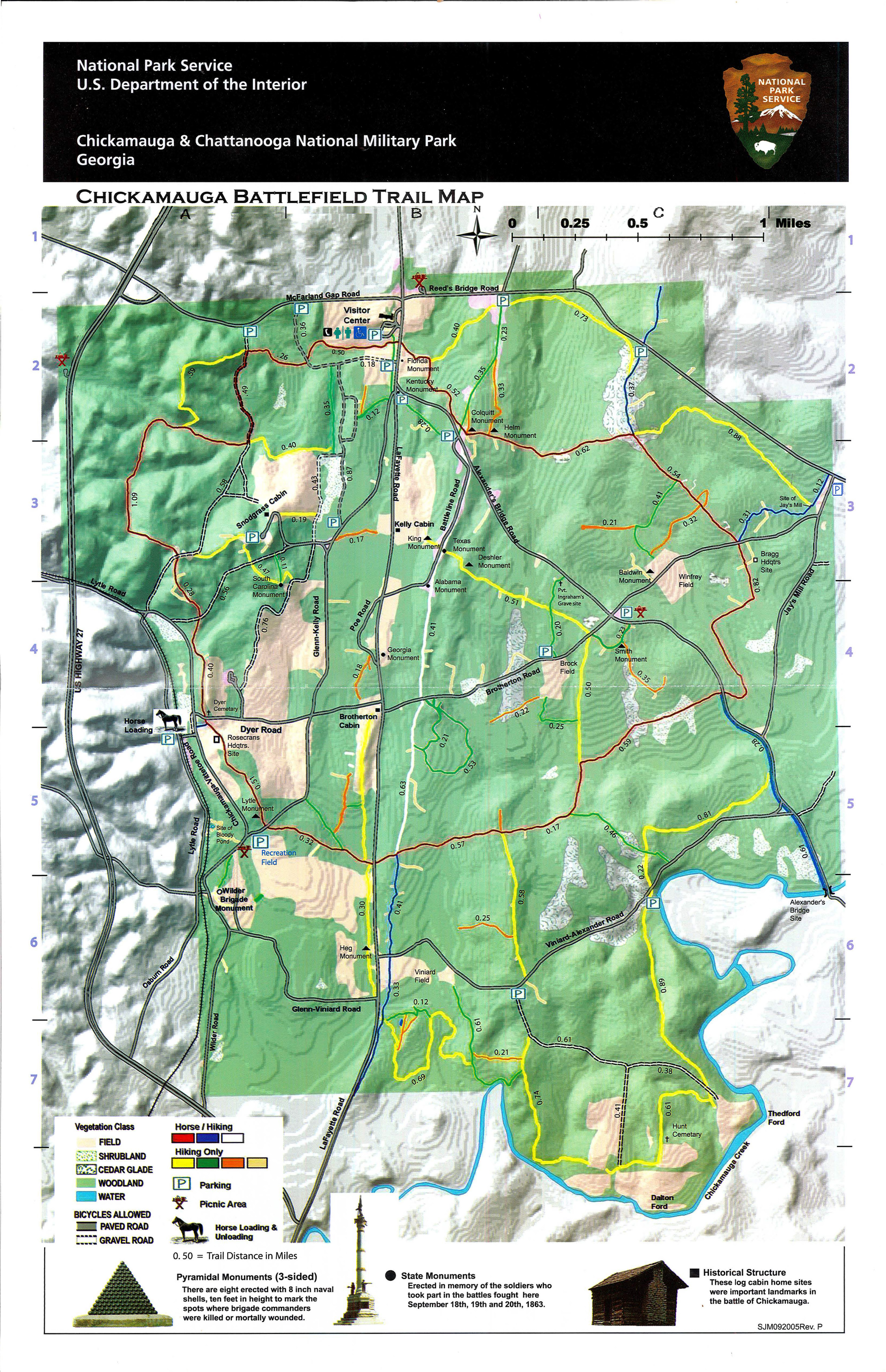
I’ve been wanting to make a trip to the Chickamauga and Chattanooga National Military Park, in Fort Oglethorpe, GA, for quite a while now. Aside from its obvious historical interest, just the Chickamauga battlefield portion of the park boasts nearly 50 miles of hiking trails. On a previous hike, we covered a few miles in the Lookout Mountain portion of the national military park, but Chickamauga’s more gentle terrain suggested that we could put in a nice loop hike and cover some ground without seriously testing our dwindling endurance.
There’s no doubt about it, my friends — these are trying times — besieged in our homes by a pandemic; so politically divided that our nation has ground down to a numb paralysis; feeling powerless against the shoots and roots from the insidious evil only partially ripped from our American soil at places like Chickamauga, Gettysburg, and Chancellorsville. In such times, it felt right to go to a place forever marked by the most extreme expression of two Americas pitted one against the other, as a reminder of what we have overcome.
The park has a great website with suggested hiking trails, and we picked out the 5-mile General Bragg trail, which is a loop made up of several segments of color-coded trails. This hike begins in the lower parking lot of the Visitor’s Center on Lafayette Road. Since this was our first visit, we didn’t really have the lay of the land (sort of like Confederate General James Longstreet, who arrived at the 1863 battle site during the night and found himself in command of the Confederate left, with no first-hand experience of the terrain and only some sketchy maps to go by in planning his attack, which was to start in a few hours). We actually drove south of the Visitor Center to a gravel lot where other trails started, but went back to the Visitor Center and parked in a paved lot south of the building, below another paved lot that was closer to the building. This is the correct starting point, though there was no signage to mark the official start of the trail. There was a worn path heading north through the grass, and it led to a wooden bridge over a creek, with an overpass to our left. The written description of the hike says to take the trail under the overpass, but when we reached the wooden bridge, there was no trail heading in that direction. To quote a historical marker we saw later in the hike, we were “thrown into confusion.”
The best option seemed to be to stick to the trail, heading south to the gravel parking lot. Once there, we looked at cannons and historical plaques detailing the units that manned the Confederate and Union artillery positions. We headed south a little farther, but when we came to an intersection with the Green trail it was obvious we had gone too far. So, like many did during September 19-20, 1863, we made a strategic retreat and crossed Lafayette Road to look at the Florida monument and another monument to an Illinois unit in the field behind. Ruth put on her metaphorical commander’s hat and came up with a battle plan — we would walk north on the shoulder of Lafayette Road to the overpass, and see if there was a trail on the other side. This was a winning strategy, as we spied a narrow track heading east down by the creek, so we walked down the grassy bank to the trail, and quickly found a trail marker that confirmed we had found the Red trail. We weren’t the first ones here to find that the maps and the ground truth didn’t agree.
This first segment of the General Bragg trail is a narrow track in the grassy field, sticking close to the woods and bending south around the edge of the field. The going was a bit soggy along the back edge of the field, as its natural bogginess was exacerbated by mud churned from horse hooves. The trails in the park vary in allowing foot traffic and horseback riding; four of the color-coded trails are hiker-only, and three are for horses and hikers. After passing a junction with the Yellow trail, we left the field and headed south, then east, into the woods. Soon after entering the woods, we crossed a little creek and sharp-eyed Ruth spotted a surprise upstream — a deer in mid-crossing!
All three of us were startled, and the deer began thrashing its way across the creek. The whole thing had sort of a “oh, pardon me, Ma’am!” quality, as if we had caught her in the bath.
The Red trail runs next to Alexander’s Bridge Road at this point, where a row of granite monuments mark the positions of various Georgia infantry units on the second day of the battle. This being a national military park, there are numerous plaques, stone monuments, and cannons scattered about on trails, next to roads, and in fields. Taken individually, they mark where units were located at various key times during the two-day battle. Sadly, the Visitor Center was closed due to the pandemic so we didn’t get a good historical overview of the battle before taking the field ourselves. I’ve since reviewed Shelby Foote’s account of the battle in his extraordinary The Civil War: a Narrative and have a better understanding of what we were looking at. Perhaps we should pause here for a brief overview.
The battle of Chickamauga was the forerunner to the battle for Chattanooga. Confederate troops commanded by General Braxton Bragg held the city in early September 1863, but retreated south on September 9, fearful of being caught between two advancing Union armies, one under the command of William Rosecrans. Bragg’s retreat was strategic though — he planted “deserters” who turned themselves in to the advancing Federal troops, with tales of how Bragg’s army was demoralized and fleeing in disarray. This was a ruse to draw Rosecrans into pursuit, which worked to a degree. However, the Confederate leadership in the western front (yes, this was considered the western front of the Civil War) had a couple of serious problems. Bragg held responsibility for a very large geographic area, and the usual political and military maneuvering resulted in numerous reorganizations of commands, which made for a disjointed command structure. One of Bragg’s two subordinate Lieutenant Generals, Leonidas Polk (who was known as the “Fighting Bishop” because he was, in fact, an Episcopal bishop in Louisiana) detested him. Bragg’s cautious nature, general disorganization on the part of his flag staff, and Rosecran’s own wariness caused a few planned ambushes to fizzle out. However, Rosecrans consolidated his scattered forces, and Bragg’s army headed north for battle, and the two forces met up on opposite sides of Chickamauga Creek. After digging in for the night on September 18, a colossal two day battle started the next day.
Our route took us into the contested spaces around the north end of the battle — the Union left and the Confederate right. Today, the battlefield is heavily wooded. It was even more wooded in 1863. The fighting was savage, contested primarily by infantry and dismounted cavalry.
Fighting deep in the woods, with visibility strictly limited to his immediate vicinity, each man seemed to take the struggle as a highly personal matter between him and the blue or butternut figures he saw dodging into and out of sight, around and behind the clumps of brush and trunks of trees.
Foote
The battle turned on a mistake by Rosecrans on September 20, acting on two incorrect scouting reports that he had a gap in the center of his line. In moving a division to fill the gap, he unwittingly created a real gap, just at the time the Confederates launched an attack at that location, directed by the veteran commander Longstreet. The Union lines broke, and the retreat was underway. Rosecrans retreated ultimately to Chattanooga, escaping annihilation of his army by heroic tactics by his subordinate commanders in covering the retreat. The ever-cautious Bragg also had a good excuse for not pursuing the Federal troops — his own army of roughly 65,000 had over 18,000 casualties. It was a horrific slaughter — ultimately the second bloodiest battle of the war, and the bloodiest on the western front. Each side had around 65,000 troops; combined, over 10,000 men were killed or missing in action, with over 34,000 combined casualties (deaths, missing, injured). Think about that for a minute — 10,000 men killed or presumed killed in two days.
Back to the hike now. After passing the Georgia monuments, we turned northeast on the Green trail, a nice wide corridor passing many monuments and plaques. In about .6 miles, we reached the northern edge of the battlefield and turned east on the Yellow trail. This was our least favorite stretch of the hike, as a good portion of it ran just south of Reed’s Bridge Road, with few if any monuments and no wildflowers to speak of. It was a nice shady level trail, to be fair.
At about .75 miles from the Green/Yellow intersection, the Blue trail merged in from the north and we followed it for about .35 miles to a junction of the Blue, Red, and Yellow trails, marked with a small cairn. By the way, this might seem confusing as you read along, because the park repeats the same blaze colors on several different unconnected trails in the park. The trail map may help clear this up! This leg of the trail was enlivened by a few wildflowers in bloom, including daisies and healall.
Daisy
Healall
At this point, we continued south on the Red trail for a half mile down to Brotherton Road. This leg of our loop had a few points of interest: (1) our standout wildflower of the hike, sundrops; (2) some tarnished Union cannons in a grove with historical plaques describing how they were taken and subsequently recovered; (3) a couple of monuments to Indiana infantry regiments; and (4) an nice healthy anole sunning itself on one of the Hoosier monuments.
Sundrops
After crossing Brotherton Road, we paid a short visit to General Bragg’s headquarters. There’s no actual structure there; just more plaques, a few clumps of false garlic, and a pyramid of cannonballs. We had one nice realization there: northwest Alabama’s own Maj. Gen. Joseph Wheeler was in action in Chickamauga. We’ve been to his house; now we can say we’ve been to his office.
False garlic
Our route took us back across Brotherton Road, where we then turned northeast on the Blue trail, which we took .3 miles to a junction with the Yellow trail. This junction was the site of Jay’s Mill, where the first shots of the battle proper were fired on September 19. Just over a shallow creek, there’s a field with the woodline to the west and Jay’s Mill Road to the east. There’s a pull-out on the road there, where a historical plaque accompanied by an audio presentation tells the story of the battle’s beginnings. To paraphrase, a Union general, acting on intel that there was an isolated Confederate brigade, sent two Union brigades to capture it. They had the poor luck to blunder into the path of Confederate cavalry wizard (pun intended) Maj. Gen. Nathan Bedford Forrest, who checked their assault until reinforcements arrived. One of the Union commanders, Col. John Croxton, found himself facing four or five brigades instead of the one he expected, and badly outnumbered. Col. Croxton then assured his place in the Smartassery Hall of Fame by sending a dispatch to his commanding general, asking which of the brigades in his front he was supposed to capture. I had to know if such cheekiness was rewarded, and in a way it was. Croxton was wounded in the battle, but survived to occupy northwest Alabama later in the war. He’ll live in infamy in Alabama (at least in some quarters) for seizing Tuscaloosa and burning most of the University of Alabama in April 1865. He survived the war, and was appointed U.S. Minister to Bolivia by President Ulysses Grant, where he died of tuberculosis in 1874.
Our route now took us back to the northwest on a .88 mile section of the Yellow trail. This stretch is also near Reed’s Bridge Road for a good part of its length, and we found it to be akin to hiking in a dry streambed. We arrived at the cairn and turned west on the Red trail, which was really just more of the same, though it did have a few stands of pale blue-eyed grass to liven it up. This segment continued west for about .6 mile, passing one of Polk’s headquarters sites and the site where Confederate Brig. Gen. Benjamin Helm was mortally wounded, one of the three Confederate BGs to lose his life at Chickamauga. He was married to a half-sister of Mary Todd Lincoln. After passing the Helm monument, we emerged from the woods next to the Georgia infantry monuments and retraced our steps to the parking lot. Though the General Bragg loop is described as a five-mile loop, our GPS track logged our hike at about 6.5 miles. Remember, we did have a false start and detoured to look at monuments.
Pale blue-eyed grass
After our excursion, we were hot and tired but had made relatively quick work of the hike, so we had time for a side trip to Naked River Brewing Company for an early dinner, some of their MoonPie Stout, and (for me) a deep-fried chocolate Moon Pie. Altogether, it was probably more calories than the average Civil War soldier had in five days. We think we identified at least ten wildflowers, with showy evening primrose and bull thistle in the mix, along with a few others, so I felt entitled. By the way, NRBC did an excellent job with social distancing.
Maybe it was the beer, or the moon pie, or the successful hike we had just finished, but I was feeling pretty good about how the day had turned out. Then I started looking at the internet, and all the hate and division came roaring back, like the crackling rifle fire at Chickamauga some 156 years ago. I watched rioters attack journalists live on Facebook in Birmingham. I saw peaceful protesters gassed and shot with rubber bullets in our nation’s capital. Generations after Chickamauga, we are once again two Americas.
With malice toward none, with charity for all, with firmness in the right as God gives us to see the right, let us strive on to finish the work we are in, to bind up the nation’s wounds, to care for him who shall have borne the battle and for his widow and his orphan, to do all which may achieve and cherish a just and lasting peace among ourselves and with all nations.
Abraham Lincoln, Second Inaugural Address
Come on, America. Bind up the nation’s wounds. Work for a just and lasting peace. That’s how you honor the fallen.
The “new normal” for now is mostly inside. I’m in my fourth week of working from home, and let me tell you, between that and the beautiful spring weather, the outdoors is looking mighty good to me right now. I’m not the only one – people are tired of being isolated in their homes, and so it’s only natural that local trails are seeing record numbers.
According to a statement on the website of the Alabama Department of Conservation and Natural Resources: “Outdoor recreation in Alabama is considered an essential activity in the Order of the State Health Officer that was issued on April 3, 2020. That means outdoors activities such as hunting, fishing, trail use, boating, and paddling can still be enjoyed by all Alabamians as long as groups are kept to less than 10 people and a consistent 6-foot distance between persons can be maintained.”
So, hiking is an approved activity, as long as you do it safely. With the Huntsville area trails seeing such large numbers of folks, here’s what I think “safely” means.
If the parking lot for a trailhead is full, consider that trail closed and move on to another one.
Stay six feet away from everybody on the trail. This means both spacing yourself out along the trail as well as stepping off the trail when passing folks coming from the other direction.
For trails where dogs are allowed, keep them on a leash! I know your little darlings long to run free, but consider that if they don’t mind you and you have to go grab them by the collar, you’re likely to end up getting closer than six feet from somebody. Avoid the issue and just keep ’em on a leash.
Be aware of places other people might have touched, like railings, kiosks, benches. Avoid them if possible.
Carry hand sanitizer and use it if you do end up touching things you maybe shouldn’t have.
Pack your trash out. This one isn’t so much for your safety as it is for the safety of those who have to clean up after you.
Bring your own water. Assume water fountains or other sources are not available.
Assume all bathrooms are closed.
The best thing to do is to find hikes that are NOT overrun with a million people, so here are three nearby places that might fit that bill.
Goldsmith-Schiffman Wildlife Sanctuary, Huntsville. This small preserve is on the Flint River and has two parking areas – one off of 431 South and the other off Taylor Road. When we visited, it was still fairly new and relatively undeveloped, but there are about three miles of trails in woods, along the river, and through farmland.
Resurrection lily (Lycoris squamigera)
White Springs Dike Trail, Wheeler National Wildlife Refuge. This trail is reachable from a small parking area off of Highway 72 on the way from Decatur. When we hiked it, we made it a 13 mile loop by combining with the Eagle’s Nest Trail, but just hike as far as you want, then turn around.
Marbut’s Bend, Elkmont – This short trail is on a TVA property off Buck Island Road. It’s an easy, flat, ADA-accessible 1.1 mile trail with lovely views of the Elk River.
We’ve done it again — gotten through another year of posts on our little blog. This was our fourth full year, with our five-year anniversary coming up next spring. Thank you, dear readers. We hope we’ve entertained you, and even better, given you some ideas and inspiration for getting out in the great outdoors.
2019 marks an interesting milestone for us. It’s the first full year in which we’ve had pretty much flat readership, in terms of views and visitors. As I write this, we’ve had 20,333 views in 2019, which is a few hundred fewer that we had at this time last year. After growth of over 50% each year for the past few years, perhaps we’ve saturated our market. We really haven’t put much effort into marketing the blog, so perhaps that’s a goal for us for next year. The truth is, we’d do the blog anyway, and we’re not generating any income from it (in fact, we pay to avoid showing you ads). We view it as a public service, and besides it gives us a good excuse to get out and explore!
Chet on a water crossing, Garrison Creek Trail, Natchez Trace.
We actually ramped up our outings this year, with 38 hikes, one float trip, and one zipline trip over the course of the year. We visited some of our old favorites for new hikes (the Bankhead National Forest, Land Trust of North Alabama preserves, multiple Alabama State Parks, and South Cumberland State Park) and discovered more new (to us) places, like Cane Creek Canyon Nature Preserve, Moss Rock Preserve, Cahaba River Park, and the Duck River Trail in Cullman) where we are likely to make return visits. We made a return visit to the Flint River for our one float trip of the year, but used a new outfitter. After taking a year off from ziplining, we tried out the relatively new course at DeSoto State Park, where Ruth impressed everyone with her Tinkerbell landings.
Fun Times
With all those outings, it’s hard to pick favorites. Ruth’s favorite is Cane Creek Canyon Nature Preserve, an amazing private reserve in Colbert County, AL. The owners allow free access on weekends to this paradise of wildflowers, creeks, waterfalls, and mountain views. Oh, and sometimes there are otters! For me, it would be our short hike on a segment of the Appalachian Trail, in the Roan Highlands bordering North Carolina and Tennessee. If you ever wonder why anyone would hike the AT, hike this section and your questions will be answered.
Here are a few other interesting tidbits from 2019 for Woodlands and Waters.
It was a return to form for us, with 52 posts (counting this one) for the year. We didn’t miss a week — hooray!
Of those 52 posts, 11 were Quick Looks and 41 were new content. Our goal was to have an even split of recycled and new content, so we far exceeded our goal.
We had views from 14 countries in 2019, with 97% of the visitors from the U.S.
We had 11,231 visitors in 2019, compared to 11,857 in 2018. It’s a slight decrease in the number of visitors year over year, but not unexpected since our views were down slightly.
Our shortest hike of the year was approximately .2 miles, a quick out-and-back to Mardis Mill Falls. Our longest was 7 miles of walking on various trails at Cane Creek Nature Preserve. (Dis)honorable mention goes to a 6.8 mile death march that we did on the North Chickamauga segment of the Cumberland Trail, which nearly got us into serious trouble with heat exhaustion.
Our total hiking distance for the year was 115 miles, up from 75 miles last year. No wonder Ruth needed a new pair of boots! Our average hike length was 3 miles.
Our one float trip was about 4.9 river miles.
Our adventures took place in four states and one foreign country: Alabama, Tennessee, North Carolina, New Mexico, and Ireland.
We didn’t have any overnight hikes, but stayed in a hobbit house in Tennessee, AirBnBs in Tennessee and Ireland, and hotels. So we’re hikers, but not campers. We did have a few fires in the firepit in our back yard, but that doesn’t really count.
We visited two private parks, seven county/municipal parks, and three Land Trust of North Alabama preserves.
We visited one state natural area, one state forest, and one greenway.
We hiked in four Tennessee state parks, three Alabama state parks, and two national forests.
We hiked in one national park and on two National Scenic Trails.
Our most popular new post for 2019 was a post about new trails on the Land Trust’s Blevins Gap Preserve, with 796 views to date. This was also our most popular post for the year, followed by our post from 2015 comparing three southeastern hike-in lodges, with 783 views this year alone.
We had modest activity in picking up followers on our various social platforms. We’re up to 73 WordPress followers now (hello, fellow bloggers!). We ended the year with 140 Facebook followers, about a 22% growth. We’ve also got 76 Twitter followers. Considering we didn’t do any marketing, that’s not bad.
In 2019, our goal was to post weekly, with new content about half the time. We met or exceeded both goals, with a lot more new content than we expected. Trips are already planned for an unusual lodging destination west of Huntsville and another trip to the mountains of western North Carolina. There are still trails we haven’t covered at Cane Creek, and Duck River looks like a good place for a bicycling trip. We have an idea for a good float trip, and we’re still in striking distance for more hikes in middle Tennessee, especially if we turn them into overnight trips. There are still new trails finished, planned or in progress on Land Trust properties and we’ll be paying them a visit. Our running list of ideas still has plenty of items on it, which is kind of surprising nearly five years into this blog.
So happy holidays, dear readers! I’m finishing up this post stuffed with eight different holiday cheeses, with a big Christmas Day dinner yet to come. We’re going to have to walk/kayak/cycle/zipline off those calories, and we’ll get started … next year.


