Quick Look: Bicycling Around Buckeye Pond at the Wheeler Wildlife Refuge


 You could say that bicycling is in my blood. In case you’ve ever wondered, yes, I am actually distantly related to aeronautical pioneers Orville and Wilbur Wright. At least that’s what my grandfather, the family genealogist, claimed. Before they were tinkering with flying machines, they ran their own bike sales and repair shop, and even had their own line of bicycles.
As a kid I rode my bike all the time, mostly around the farm and up and down the gravel road that ran past it. Like just about every boy my age, I learned my limits the hard way — by being launched by unseen potholes into brief terrifying moments of being unintentionally airborne, or by having my body grated by blacktop roads unforgiving of miscalculations on the variables of speed, momentum, road width, and the radius of a curve.  But the occasional bruise and/or skinned body part was an acceptable price for the freedom of having my own wheels and the opportunities that came with them. At the time I thought nothing of it, but as an adult now I marvel that my parents casually accepted my blithe announcements that I’d be out working on my six 25-mile rides for my bicycling merit badge, and I’d be home for dinner. I think I was 14 at the time. And I never missed dinner, and I still have the merit badge.
As an adult, I rarely get a chance to pull the bike down off the rack in the garage, but I enjoy it when I do. Our recent nice ride on the Richard Martin Trail whetted my appetite for a return to the Wheeler National Wildlife Refuge. The Wheeler is a great place to hike and bike, and especially a great place to birdwatch. There are several miles of gravel roads, mostly flat or with gentle grades, on the reserve with very little vehicular traffic to dodge. I picked out a 12-mile loop on the northern side of the Tennessee River between Redstone Arsenal and Decatur and we set off in the morning.
Our starting/ending point would be a gravel parking area off Jolly B Road (spelled as “Jolley B” on some maps). To get there, turn south on County Line Road, and just before it ends turn left onto Jolly B Road. Jolly B starts as a paved road, but soon splits with one fork going left into the Refuge, the other fork going right to a farm, and both forks turning into a gravel road. Once you get onto the Refuge, travel with care (actually, travel with care the length of Jolly B — the paved portion has a sharp curve). The gravel roads on the Refuge have some pretty substantial potholes in them. You can get any vehicle with normal clearance down to the parking area, so there’s no need for four-wheel drive, but if you try to do the Dukes of Hazzard stuff on the Refuge roads, you’ll soon find out what it costs to replace an axle. I don’t know how Jolly B Road gets its name, but I think it might stand for “Jolly Breakdown Road.” After the road turns to gravel, the parking area is on the right, with one gravel road taking off to the west and Jolly B continuing to the south.

 Our ride started from the parking area along that road to the west, identified on maps as HGH Road. There are no road signs anywhere on this part of the Refuge, so it’s a good idea to bring a map with you. We stopped to admire the stands of great ragweed and snow squarestem growing at the edge of the parking area, with muscadines twining up into the trees, then we set off along the straight, flat doubletrack of HGH Road. My best efforts at Internet research have failed to ferret out why this road (and another we’ll ride on later, JTT Road) are only known by initials. My guess is they are named for the initials of landowners at the time the land was purchased by TVA in the mid-1930s. Or perhaps they are the initials of former Refuge supervisors. Can anyone shed any light on this, dear readers?
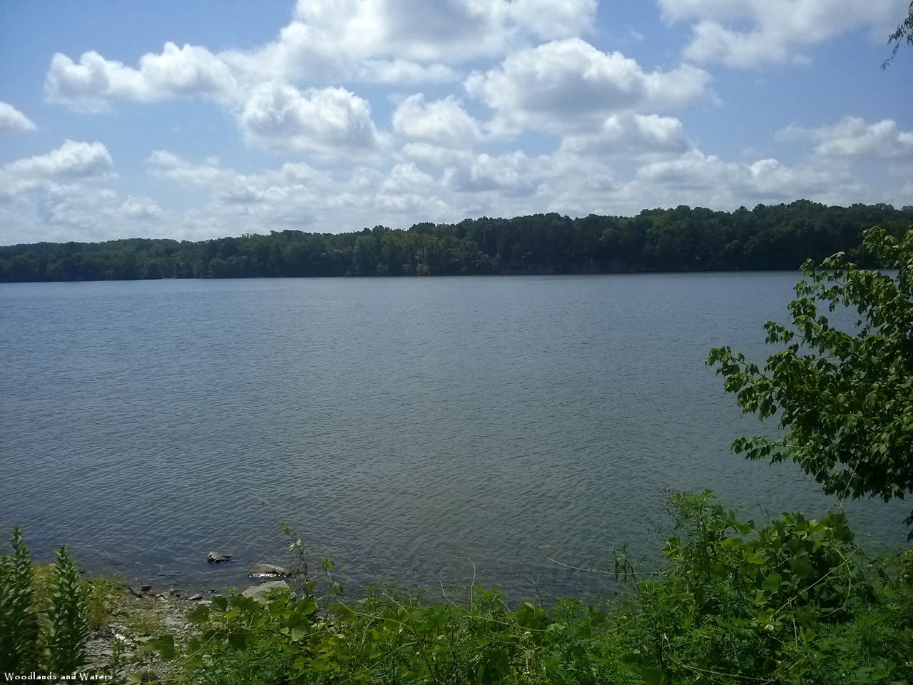
HGH Road continues west for 1.5 miles, pretty much straight and level, under the shade of the trees. There was a good supply of our typical late summer wildflowers on the roadsides with asters and jewelweed being easy to spot as we rolled along. HGH Road takes a curve to the north, with a closed gate to the southwest marking a possible route to return to Jolly B Road. We turned north, next to a harvested cornfield. This stretch opens up, running between fields with a thin strip of woods to the west screening Buckeye Pond. This was one of the few downhill stretches on our ride.


We continued winding north and west as the road curved gently back into the woods. We saw stands of lovely mistflower here, and noticed our old friend the Devil’s walking stick in several locations, with its profuse crown of berries. About 2.9 miles from the parking area, HGH clears the top of Buckeye Pond and forks, with the right fork leaving the Refuge toward a house on New Hope Road. We took the left fork and headed south, skirting the western edge of the pond.


The west side of Buckeye Pond is pretty similar to the east side. HGH Road continues to the south, with very little grade change. At about 4 miles from the parking area, HGH Road tees into John Gordon Road, running east-west. Remember what I said earlier about bringing a map? Well, I should have taken my own advice. We turned east on a dirt road, toward Buckeye Pond, and it was a serendipitous choice since it took us to the pond itself. Though HGH Road winds completely around the pond, there’s always a barrier of woods blocking the view of the water from the road. Our side road quickly led to a huge open field, with the northern reaches of Buckeye Pond straight ahead. As we rode toward the pond, a gorgeous great egret took wing, curving over the field to disappear into the distant woods. The road was completely spanned by a large and deep puddle, but we were able to find a track to get around the obstacle and continue to the southwest until our road, now a grassy track, stopped completely in a thicket. Clearly this wasn’t our planned route, so we backtracked to the field and headed back toward John Gordon Road.
 As we returned to the field, we saw a large bird take off to our left, loudly gronk-ing as it flew south away from us. It was a familiar sight — Brad the grumpy Great Blue Heron! We always seem to run into him when we go to the Wheeler, and he was in his usual fowl (ha!) mood. He offered to fly down and peck another hole in my bicycle tire, but I declined his kind offer.
 After retracing our route to John Gordon Road, we rode west for about .15 miles before re-entering the Refuge by turning left onto JTT Road, which climbed a small hill to reach an intersection at the top. To the east, a gated track led back toward the southern end of Buckeye Pond. The more obvious route is to the west, so we took JTT Road until it teed into Rockhouse Road (heading north outside of the Refuge) and Rockhouse Bottoms Road (heading south toward the river).
  We headed for the river, reaching it in about .25 miles, and pulled the bikes over to have a bit of lunch while perched on some rocks on the bank. I had picked up a muscadine on the road earlier in the ride, so I had it for dessert.
After lunch, we headed east on Rockhouse Bottoms Road along the north bank of the Tennessee River. Since we were on river bottomland, the level road was flanked by the river on one side and planted crops (maybe soybeans?) on the other. I noticed quite a lot of fragments of mussel and aquatic snail shells in the tilled earth.
Rockhouse Bottoms Road was relatively busy. It has unpaved access to the river in a few places, so it’s a popular place for launching small boats, and we saw at least one angler on the riverbank. We met a couple of cars making their way slowly down the road. Since it is more heavily traveled than the other Refuge roads we had ridden on our trip, it’s not surprising that it is much more potholed. The potholes are easily dodged, but you’ll need to pay attention, which is difficult when there are such lovely river views.


The ride along Rockhouse Bottoms Road is a little over 4 miles, with a few stands of yam leaf clematis growing on the roadside as your near the northward turn back onto Jolly B Road. After rejoining Jolly B and turning left (north) to close the loop, it’s only about .9 miles back to the parking area. On the way north, there are a couple of places where you can get a good look at Blackwell Swamp if you’re so inclined.


All in all, it was a triumphant return to the Wheeler. The bikes were in fine fettle, the weather was clear and warm, there were several showy late summer wildflowers in bloom, and the ride itself was good exercise without being too tiring. We covered 12.3 miles according to the GPS track, and best of all, we were home in plenty of time for dinner.

Almost exactly a year ago, Chet and I took our bikes over to Wheeler National Wildlife Refuge for an adventure. We had a great time, up until the point where Chet’s front tire had a complete blowout, leaving him walking with almost 2 miles left to go to get back to the truck. Honestly, my bike wasn’t in much better shape but at least I didn’t have a flat so I biked to the truck (praying the whole time my frayed tire wouldn’t give out) and hustled back to pick up Chet and his wounded machine. We returned to the house and hung the bikes up in the garage – all the while telling ourselves we’d take them both to the bike shop for a full tuneup and new tires soon. Months went by and those bikes were still hanging in the garage. Winter passed, then spring, then most of the summer, but finally we managed to bestir ourselves and took them in for some much needed TLC. This past Saturday, they were ready. And even more miraculously, we remembered to pick them up. Ok, so we didn’t really remember until 15 minutes before the shop closed, but we roared up just before the doors locked and the good folks at Madison Cycles graciously stayed open long enough for us to retrieve our now shiny and newly refurbished bikes.
Knowing the bikes should be ready, I’d already planned our weekend adventure around having them. Sunday morning, we packed up a lunch, some water, and Chet’s camera, threw the bikes in the back of the truck and headed to Piney Chapel Road in Athens, Alabama. This is the location of the southern end of the Richard Martin Trail, a rails-to-trails project that has taken an abandoned rail line and turned it into a multi-use trail for hikers, bikers, joggers, and horseback riders. We’d explored the northern end of it before, riding from Veto, Alabama down to Elkmont, but now was the perfect time to check out the rest of the trail.
The parking area at this southern end is a roomy gravel lot with room for 10 or more pickup trucks and trailers. The area also featured a very nice picnic pavilion in a lovely grassy setting, and a new cinder block building housing restrooms. We didn’t hang around to check out the amenities, though, but instead crossed tiny Delaney Road to get a start on the trail itself.


Technically, the trail starts at the corner of Delaney and Piney Chapel roads. Crossing over from the parking lot puts you a few yards north of the intersection so, being a bit of a nerdy engineer type, I insisted on walking a few yards back towards Piney Chapel Road so we could start at the official “Mile 0” sign. From there, I was interested to find that you could still actually see the rail line, complete with rails and railroad ties, just across the street, heading south. Of course it makes sense – this was a working rail line until 1986 and before the Civil War the track was a part of the Decatur-Nashville railroad, one of the first rail lines in the area. The Richard Martin Trail has just reclaimed the 10 mile stretch between Veto and this intersection in Athens. We took a few pictures, enjoyed the morning glory and Carolina buckthorn blooming by the trail, then headed down the inviting gravel path.


One nice thing about a rails-to-trails project is that the railroads have very nicely already graded the entire thing for the benefit of the trains that used to rumble down the tracks. These trails are generally well-engineered, wide and gently graded pathways making them ideal for bikes, in my humble opinion. While there is some rise and fall in the terrain, none of it is very steep, making for easy rides. The first stretch of the Richard Martin trail is practically level. The wide path plunges almost immediately into a lovely deeply shaded wooded area surrounded at first by grassy glades interspersed with large oaks. We had the path to ourselves, at least at first, and enjoyed the cooling effect of the air rushing past us. At the .6 mile mark, we came to our first bridge across Swan Creek. It’s in a little bit of a rough condition, with plywood patches here and there across the deck. It was solid enough otherwise, though, so we just continued on across it. Soon after, at 1.25 miles, we came to a prettier covered bridge also crossing Swan Creek or maybe one of its tributaries. Here we stopped again for pictures and noticed a stand of Florida blue lettuce, and some beautiful cardinal flowers along the water, with an added bonus of an absolute carpet of jewelweed in bloom in the foreground. Chet also spotted a mysterious plant with a large cluster of berries. We puzzled over it and took pictures, but couldn’t come up with an ID on the trail. Once home, we figured it out … and felt a little silly. It was a devil’s walking stick. I’ve never seen one when it had berries before and totally missed the dead-giveaway spines running up the trunk! My tree ID ninja skills are rusty!


We continued on through the trees, glimpsing fields and farmland occasionally to either side. Every half mile, there is a small wooden sign posted with the mileage from the Mile 0 marker where we’d started. This sure made it easy for me to figure out how far we’d gone so that I could remember where on the trail we saw things! At about 1.5 miles, we came to our first road crossing at Huber Road. This is a small road and lightly traveled, at least on Sunday mornings, so we had no trouble crossing it. The trail heads back into the woods on the other side for another half mile or so before coming out to an open area alongside Railroad Lane. Less than a tenth of a mile away was our second road crossing, this time at the slightly larger Hays Mill Road. On the other side of the road, there is a large information sign about the Rails to Trails project with rules and hours – as if this was an official trailhead of some sort. There’s no parking here, though, really so I found it kind of odd. Maybe the trail stopped here at one point?


Past the sign we entered maybe my favorite stretch of the trail, a section that runs right alongside Swan Creek at a spot where the creek broadens and slows down to form a bayou. The water is still and algae covered and floods a glade of trees so that the trunks reflect and shimmer in the water. It’s dark in the shade of the trees, and quiet. At least until I stepped close to the bank, which startled frogs hiding there so that they squeaked and jumped in the water. I’ve never heard a frog squeak before, but that sure is what it sounded like! I kept a sharp eye out for turtles, but sadly, saw none. We rested on a nicely built bench placed there courtesy of BSA Troop 235, had some water, and enjoyed the quiet until the bugs convinced us to move along.


The next mile and a half was uneventful as we flew past trees and fields along the gravel path. Soon, though the landscape changed a bit to include some small hills around us as we approached the historic site of the Battle of Sulphur Creek Trestle. This Civil War battle, a part of the longer Battle of Athens, happened September 25, 1864, when Confederate troops led by Nathan Bedford Forrest set out to destroy the strategic trestle at Sulphur Creek. By noon that day, the Union force surrendered. It’s not clear to me if the actual trestle survived that battle, but I can tell you that there is no sign of it now. You can see Sulphur Creek far below on either side of the pathway, but instead of a wooden trestle, the path goes along a pretty solid-looking earthworks. On the other side of the creek, the land rises up a bit again, then slopes back down towards Elkmont, about a mile away. Close to Elkmont we started noticing some extra wooden sign posts. Not the mile markers – we still had those – but these were posts with smaller numbers carved into wood. We saw “13,” “15,” and “16” if I remember right.


We pulled up to downtown Elkmont right at 11:00 – lunch time! The church on the corner had a full parking lot, but otherwise Elkmont was practically deserted except for the two of us and another family setting out on bikes down the trail towards Veto. We snagged a prime spot at a concrete picnic table, ate our sandwiches, then wandered the quaint one block downtown and took a few pictures before heading back. It was too early for any of the businesses near the Depot to be open. Before we left, we looked around the parking lot at the Depot to see if we could find any kind of flyers for the mystery marker posts. We found what looked to have once been a pamphlet box, but the box itself was long gone – maybe knocked off by vandals. I guess we’ll never know what those posts are marking!


The return trip took us back through the same sights, but we did spot some things on the trip back that we’d missed on the way out. Just after the bayou and before the crossing at Hays Mill Road, Chet spotted some old railroad ties and a broken cement marker with the letter “W” incised into the concrete. Later research revealed that this may have been an old “Whistle Post”- a sign placed by the tracks so that engineers would know when to sound the whistle on the train. I’ve included a picture of the broken post below. What do you folks think?


We crossed back over Hays Mill Road, noting that coming from this direction it might not be obvious where the actual trail is. Stick to the faint gravel path to the right of the paved Railroad Lane. Farther along, I stopped to admire the cardinal flowers I’d missed on the way out, while Chet admired a muscadine vine with actual muscadine grapes. He’s often talked about how muscadine vine is something we see everywhere, but he’s never seen an actual grape in the wild. Well, he can’t say that any more!


All in all this was a very pleasant 11 mile bike ride. It was August in Alabama, but the shady path was cool, and the air rushing past as we whizzed along on our newly refurbished bikes was even cooler. Now I’ll be on the lookout for some more bicycling adventure spots. Any suggestions?

On one of our previous trips to the Wheeler National Wildlife Refuge, we noticed that while the Wheeler has relatively few officially designated trails, it has a network of well-maintained gravel roads that are good for hiking and are great for cycling. In our quest to find outdoor activities in which we get a little relief from the Alabama summer temperatures, we thought we’d try out some of those roads on our bicycles.
The Wheeler is a 35,000-acre refuge for migrating birds, scattered in various parcels along the Tennessee River from Decatur to Redstone Arsenal. It’s well worth a visit, with boardwalks, trails, and gravel roads providing access into the sloughs, wetlands, woodlands, and fields. Its wide variety of habitats makes it a great place to watch not only birds, but also many species of reptiles, amphibians, fish, and mammals. Botanists can also find much to enjoy there, with bountiful wildflowers in bloom almost year-round.
Our particular route for this trip was to drive south on County Line Road, south of I-565, to almost the end of the road. We turned left on the splendidly-named Jolly B Road, and followed it for about half a mile until it forked, with a clearly-marked entrance to the Wheeler. From that point, we drove another half mile down the gravel road to a junction with the more enigmatically-named HGH Road, where a large gravel parking area provides space for several vehicles and even room for a horse trailer or two. I should note that there are no road signs on this part of the Wheeler, so you’re well-advised to have a look at the map before setting out.  In the description below, I’m making my best guess as to the names of the roads we traveled. We were the only folks there on a Sunday morning as we unloaded the bikes, put on our blaze orange, and got ready to hit the road. Why the blaze? Though the Wheeler is a wildlife refuge, it’s only a refuge for our feathered friends. Hunting is allowed on the preserve with proper permits, and it’s always hunting season for something in Alabama.
Our route was a simple one. We planned to make a counter-clockwise trip around the Blackwell Run, a body of water referred to as a stream, a swamp, or a lake. I’d call it a body of water about 2.5 miles long, fed by small creeks and runoff, which empties into the Tennessee River. A gravel road (labelled on maps as Blackwell Run Road) encloses Blackwell Run, forming approximately a 7.4 mile loop.  We started the loop from the parking area, turning right and heading south along Jolly B Road. The wide, level gravel road made for easy biking. The surface was pulverized gravel and dirt, with occasional potholes that are easily avoided. Most of the route is in partial or complete shade, so we were able to keep cool by pedaling along leisurely and generating a small breeze.
 Less than a quarter of a mile into the ride, we got our best look at Blackwell Run, or at least a swampy portion of it, from a pullout on the left. The swamp was an impressive sight, with water lilies interspersed with other aquatic vegetation among the knobs of trees sticking up from the water. Though we didn’t see any waterfowl this time, I expect this could be a good place to spot them. Just a short distance after that, we spotted the first drainage canal and floodgate of the trip.
  The Wheeler has a complex drainage system used to route water away from some areas, such as fields planted to provide food for the birds, and to flood other areas to create wetlands habitat. This particular one was open, creating a deep, still pool which, to Ruth’s delight, had a small turtle swimming around in it.
One notable thing about this trip was the abundance of late summer wildflowers. We spotted several showy examples along the road, such as halberdleaf rose mallow, tall ironweed, butterfly bush, red clover, common evening primrose, and a couple others we haven’t yet identified.


The flowers themselves were great, but an even better side effect was the plethora of butterflies we saw all along this ride. We didn’t get many photos, but I know we saw at least eight different varieties out flitting about.
 About a mile into the ride, we came to a fork in the road. To the left, Blackwell Run Road turns east and runs between Blackwell Run and the river. To the right, Rockhouse Bottoms Road runs westward along the banks of the mighty Tennessee. Though we planned to circle the swamp, we also wanted to try a side jaunt along the river, just to get the flavor. So we went right, on a long curve that quickly put us on the riverbank. There are a couple of pulloffs on the left side of the road that give access to the river. We stopped at one to admire the view, and passed a couple of others with fishermen trying their luck. These pulloffs would also be suitable for launching a canoe or kayak, but I think it would be a bit dicey to try to launch a larger boat from them.
 We pedaled along westward, on a nice wide, dead-level road, with shady trees to the left and a soybean field to the right. Rockhouse Bottoms Road continues for four miles along this stretch of the river before turning north and connecting into other roads.
  We went a little over a mile before turning around and riding past the kudzu jungle on our way back to the junction with Blackwell Run Road.
 After resuming our ride around the swamp, we quickly came to the south end of Blackwell Run, a murky green slough disappearing through the trees in the direction of the river. We heard a big splash as we rode past this pool. We didn’t see what caused it, but I’ve read that many of the alligator sightings in the Wheeler have been in the Blackwell swamp. Hmm, something to think about….
 The road reached the riverbank and continued eastward for .8 mile before coming to a prominent access point to the river. We wheeled over to have a look and startled a large blue heron, who silently rose from the bank and soared across the river. It might have been Brad, the grumpy blue heron from our earlier trips to the Wheeler but he didn’t hang around for any conversations this time. Ruth couldn’t resist sticking a hand in the river, only to note with mild disgust, “Ugh, it’s like bathwater.” I guess we’ve been spoiled by cool mountain streams!
At this point the road turns northward and away from the river. The surface changes a bit here. It’s still a gravel road, but the east side of Blackwell Run seems to stay a little damper. The gravel is a little larger and is packed down into dense mud, so the ride becomes a little bumpier here. The road also split, with a drier fork to the left and a large puddle blocking the entire road to the right. We went left, which paralleled the road to the right, so I suspect it’s just a workaround for a particularly boggy spot.  Property lines cause the road to have a zig-zag effect on this side of Blackwell Run, but the road stretches straight for a least a quarter mile before making a curve to the left or right. About a mile from the river we came to one recognizable landmark on this section of the ride — a sewage treatment plant on the right. The odor wasn’t too bad, but we both picked up the pace along this stretch and soon left the smells behind and entered a very shady (in the original sense of the word) corridor.
This part of the ride was slightly more challenging, with a handful of small inclines, the bumpy surface, and potholes that had a bad habit of popping up unexpectedly as we were enjoying the few downhill sections.  It’s still an easy ride, suitable for kids, though keep an eye out for one dip that extends completely across the road about a half mile past the sewage treatment plant. It’s no problem on a bike but would be pretty exciting if you took it at speed in a motorized vehicle.
I was really enjoying being in the shadow of the trees, a cool breeze on my face as I cruised past the wildflowers and among the butterflies. It actually felt like a warm spring day instead of a summer scorcher! But my blissful ride was soon interrupted by a loud pop and the sound of rushing air from my front tire. Yep, it was a flat — a complete blowout. When I inflated the tires at home before heading out, I noticed that they looked like they had some dry rot and would need to be replaced soon. Well, soon is now. We were 7.6 miles into the ride, and I knew we had around two miles at least to get back to the truck. We weren’t carrying a pump, not that it mattered with the tube shot so badly, so repair wasn’t an option. After a quick conference, we decided Ruth would ride on ahead and complete the loop, then come back and pick me up in the truck. Of course, that was assuming she wouldn’t get a flat too! We both had our cell phones, so off she pedaled while I played hike-a-bike along the road, stopping to snap a few photos of butterflies along the way.


Ruth made quick work of the rest of the ride, reaching the north end of Blackwell Run, then continuing westward for about .25 mile before turning south and continuing along the road through the woods until it intersected Jolly B Road just north of the entrance to the Wheeler. From there it was a short hop to close the loop and return to the truck, where she called and texted me to let me know that rescue was on the way. Cell reception isn’t great in that part of the county, but the message got through. Soon she arrived on the horizon, I loaded up the bike, and we turned around and headed back toward Jolly B. After having been in the saddle, it was a surprise that the road was so rough in a truck!
Though I didn’t complete the ride, Ruth made the complete loop to finish a 9.9 mile ride. Despite the abrupt end to my ride, I really enjoyed this trip. The road surface is decent, the terrain is mostly flat, there are very few vehicles, and there are plenty of great views. I’m already looking forward to riding more in the Wheeler. That is, after I get the bikes back from the shop!

Everything looked pretty glum on Sunday. It was the worst day of the year – the “Spring Ahead” day where you lose an hour of precious, precious sleep – plus the weather forecast was for rain in the morning and then more rain in the afternoon. I dragged myself out of bed that morning, grumpy about the time change and just sure that we wouldn’t be able to get out and have any sort of adventure. Chet and I had spent some time the evening before kicking around ideas for what to do if we thought the weather would cooperate, but we hadn’t really come up with a plan either of us were excited about. Once again, I was thinking rain=great waterfalls so that led me to thinking about Middle Tennessee waterfalls. However, I wasn’t really loving the thought of driving 90 minutes only to have the skies open up on us. Remember, Chet does not like hiking in the rain at all. A direct quote from him is “I’m miserable when I hike in the rain, and I probably wear an expression like a cat tied to a water sprinkler.” You can understand why neither of my options at that point – hiking with said cat tied to a water sprinkler or giving up and spending 3 hours in the car for no hike at all – was something I was looking forward to.
We started thinking about things closer by that we could do and I suggested maybe we could try out the Richard Martin Trail near Elkmont. This is a Rails to Trails Conservancy project, which takes abandoned railroad corridors and turns them into multi-use hiking, biking and horse trails. This particular trail goes from Veto, Alabama in the north down to Piney Chapel Road near Athens in the south, passing through Elkmont at about the halfway point. Here’s where Chet had a brainstorm. Since we were a little worried about rain still – why not throw the bikes in the truck? That way we could plan to go from Veto to Elkmont and back, maybe even before the rain got here, but if we got caught in the rain at least getting back to the truck would be quicker on a bike. Brilliant! We wrestled down the bikes from their storage hooks, added air to the tires, and took off to Veto.

The parking lot for this northern end of the Richard Martin Trail is on the corner of Veto Road and Cave Branch Road, which also happens to be the Alabama/Tennessee state line. Veto, Alabama is an interesting place. According to Wikipedia and other sources, this small unincorporated community was originally called “State Line,” then changed its name to Veto after a community of that name just across the state line. There was a post office there from as early as 1875 up until 1950. Now all we could see was a restored Methodist church, a building that may have been a general store, and a scattering of old houses. The historic markers outside the church had a map of Veto that made the town look more substantial, but I could find no evidence later on Google Earth of the other roads that should have been there. The church is charming though. It was originally built by a Methodist-Episcopal South congregation under an oak tree off what is now Bob Coffman Road in February 1886. It remained in use until the 1960s when membership had dwindled to 9 and the 5-member Gates family moved to Athens. It was used for storage until sometime in the early 2000s when local recreation officials arranged to buy it and move it 250 yards onto land belonging to the Richard Martin Rails-to-Trails project. The plan at that time was to raise the money to restore it and use the 120 year old building as a shelter for hikers and a wedding venue. When Chet and I were there on a Sunday morning, it was locked so I don’t know if that plan has been put into action or not but I hope so!


After a brief look at the plaques in front of the church, we started down the gravel path that is the trail here. Almost immediately, I was startled by a bird running along the ground right at me. It then turned and ran into the grass and started flapping around like it was injured. I’d heard of this behavior before but never seen it. It’s called a “distraction display.” A parent bird will fake being injured to draw a predator away from its nest, which is typically on the ground. This bird was determined. She (?) ran toward us until she got our attention, then ran to the grass along the side of the trail and started making a distress call and striking an “oh poor me my wing is broken” pose. She had orange feathers on her rump, bands of black and white on the ends of her wings and a white ring around her neck. As soon as we were far enough away from her nest, she miraculously healed and flew off. When we got home we compared our picture with some on the web and discovered she must have been a killdeer.

Other than the church, the first mile is probably the least attractive part of this trail. It’s just a gravel track between two roads. There are some houses – one with a lot of chickens roaming around near the mailbox – but not really anything terribly scenic at first. Then the trail cuts into the woods and it’s really very pretty from there on out. It is mostly in the trees, crossing several creeks along the way. As we rode we saw a couple of different sorts of sign posts. One is the mileage from the southern end of the trail, posted every 1/2 mile. The other is a post with a number on it. The Veto starting point had a box that looked like it might contain pamphlets of some sort, but it was empty. I’m assuming maybe it usually holds descriptions tied to these numbers.


After crossing a couple of roads and going over a small bridge we passed the entrance to Mill Creek Park – a large RV park. I’m not an RV camper myself, but this looks like a nice one. It’s large and seems pretty quiet and has great access to the trail and the Elk River. If you’re an RV type – check it out!
Next up was a beautiful covered bridge over Mill Creek. There was obviously an old railroad trestle at this point – you can still see the stone foundations in the creek below. About 1/2 mile after that there is another bridge, this one not covered, over a feeder stream for Smith Creek. After this second bridge, the trail climbs gently, but incessantly, uphill. One of the benefits of this being an old railroad corridor is that since trains don’t really “do” steep inclines, neither will you. I was huffing and puffing just a bit up this part thinking “boy, this will be a blast to coast down coming back!,” but it really wasn’t that steep. I’m not in “bike” shape I guess. Here, the trail has curved pretty far away from Veto Road and all you can see is the woods climbing up to the right and occasional fields, ponds, or barns to your left.


As I came close to the top of a rise I could see … something … alongside the trail up ahead. My eyes are not the best, so I wasn’t sure from a distance if I was seeing a dog or a clump of windblown trash. Turns out I was wrong on both counts – it was a herd of about eight goats! They were chillin’ there on the trail. When they saw us coming they got up, crossed the trail, sort of stared at us a bit and then bounded down a really steep path down to the little farm nestled in the valley below. I wonder if those were some of the Belle Chevre goats? Belle Chevre is an artisanal goat cheese maker that got its start in Elkmont. They have a shop in downtown Huntsville as well, have won numerous awards and have gained a national reputation.

Shortly after the goat-spotting, the trail merges briefly with the road to the goat farm, then crosses over Smithfield Road and back into the woods for the final stretch into Elkmont. Elkmont is a quaint and quiet little town. It has an few old buildings – the old depot which acts now as a senior center, one place that looked like a cafe, and Belle Chevre has a tasting room in another old building across the street. It was pretty quiet on a Sunday morning – I believe we had the place to ourselves. I do have to say that I was regretting my choice for a second cup of coffee right about this point and was very happy to see that the Depot building has free and open restrooms at one end of the building. We looked around a bit, had a snack of peanut butter crackers and then headed back up the road to Veto.


The ride back was not nearly so much of a downhill coast as I was expecting, and the last mile before we got back to the church was uphill which neither of us had noticed at all when we came down it! Mama Killdeer was nowhere to be found, which I was a little disappointed about, but we made it back without getting rained on one bit – we even saw a bit of blue sky as we were driving back to Huntsville. All in all, we covered around 10 miles and half of the Richard Martin Trail, saw a killdeer doing its distraction display, startled a goat family, saw some early spring wildflowers, and saw lots of pretty scenery all without any signs of the cat tied to a sprinkler. I call it a good morning!


